Severe thunderstorms will continue through early afternoon for portions of the Ohio River Valley and south to the Gulf Coast. Across the Northern Great Lakes, moderate to heavy snow will be likely. Snow and light ice will be possible for the Upper Northeast.
Current NWS Advisories/Watches/Warnings in iMap Pro:
The squall line that developed along the frontal boundary over the Great Lakes will continue to move eastward through the day. The highest chances for severe weather will remain from the Northern Gulf Coast through the Ohio River Valley. Damaging winds, hail, and an embedded tornado will be possible before the storms lose their strength during the late afternoon/evening.
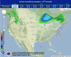
Moderate to heavy snow is expected for portions of the Great Lakes, as well as some icing. Heaviest amounts are expected through Northern Wisconsin and Michigan with accumulations of 6-12 inches with isolated higher amounts. In addition, portions of Wisconsin and Michigan could see a tenth to a quarter inch of ice. Wind gusts to 30-40 miles per hour will cause drifts and blowing snow. Light icing will also be possible for portions of New York, Vermont, and New Hampshire. Accumulations will remain under a quarter of an inch.
WDT preferred forecast for 24 hour snow and ice accumulations through 7AM CDT Saturday