


by WeatherOps, on May 5, 2014 12:29:50 PM
A large upper level trough will move into the Plains Tuesday night into Wednesday, bringing a potential for severe thunderstorms to portions of the Central and Southern Plains.
SPC Convective Outlook for Wednesday

As the upper level trough approaches the Plains, a dryline will set up across the Western High Plains and move eastward through the day on Wednesday. Thunderstorms will develop ahead of the dryline across portions of Kansas and Oklahoma. As thunderstorms develop, large hail and damaging winds will be the main concerns. The tornado potential will be highest across the Northern Plains where the shear is strongest and LCLs are lower.
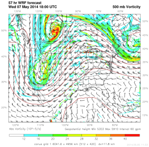
500 mb vorticity and surface dewpoints 1pm CDT Wednesday

As the system continues to progress eastward, severe thunderstorms will also be likely for portions of the Ohio River Valley, Great Lakes, and Mid Atlantic toward the end of the week.
