


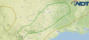
by WeatherOps, on Jun 24, 2014 12:27:20 PM
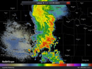
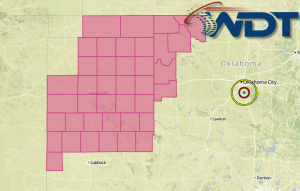
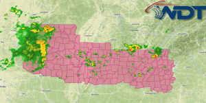
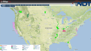
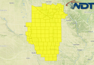
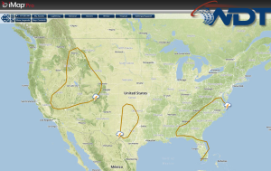
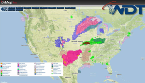
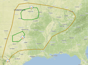
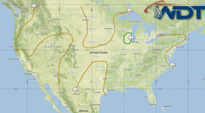
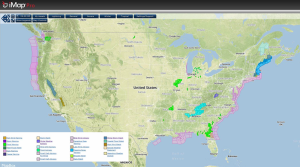
Thunderstorms are moving across portions of Western Texas and may move into portions of Southwestern Oklahoma. While no severe weather is expected, small hail and gusty winds will be possible …
Read Storyby WeatherOps, on Jun 24, 2014 9:57:25 AM
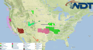
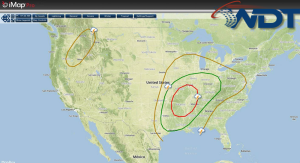
Severe thunderstorms are possible today across the Colorado High Plains. Strong thunderstorms are possible for the Lower Great Lakes and the Ohio River Valley. NWS Advisories/Watches/Warnings in iMapPro: Today's primary …
Read Storyby WeatherOps, on Jun 23, 2014 4:20:14 PM
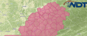
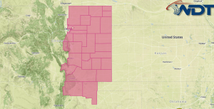
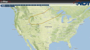
Severe thunderstorms will be possible for portions of the Colorado High Plains on Tuesday. Thunderstorms and gusty winds will be possible for the Lower Great Lakes. The primary concern will …
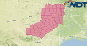
Read Storyby WeatherOps, on Jun 23, 2014 12:29:06 PM
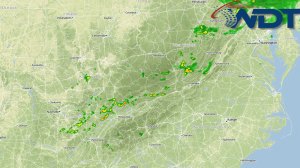
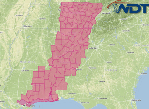
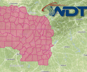
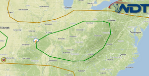
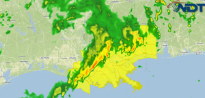
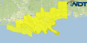
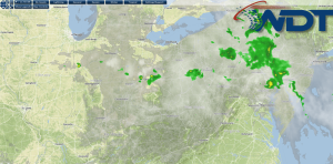
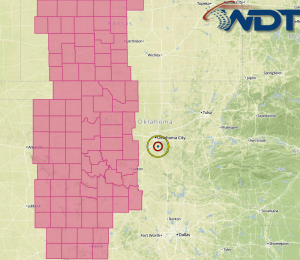
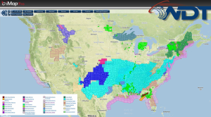
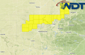
The storms that moved through portions of Oklahoma and North Texas are now across Central and Eastern Texas and will continue to move to the east. Further thunderstorm development is …
Read Storyby WeatherOps, on Jun 23, 2014 9:47:07 AM
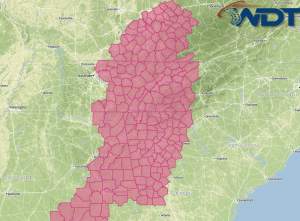
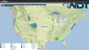
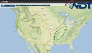
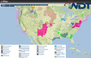
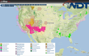
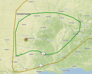
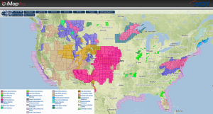
Severe thunderstorms will be possible today for the High Plains of Colorado, as well as Texas through the Ohio River Valley. Current NWS Advisories/Watches/Warnings in iMapPro: Today's primary severe weather …
Read Storyby WeatherOps, on Jun 20, 2014 4:28:00 PM
Thunderstorms will be possible on Saturday from portions of the Midwest to Tennessee Valley as well as the Southern Plains. The severed risk will be low on Saturday as high …
Read Storyby WeatherOps, on Jun 20, 2014 3:43:58 PM
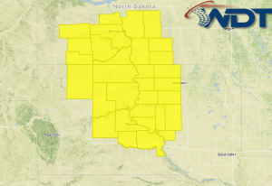
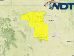
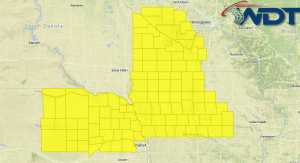
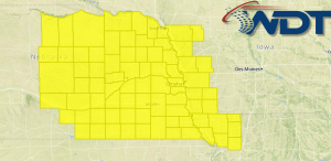
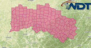
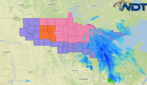
A Severe Thunderstorm Watch is in effect for portions of the Dakotas and Minnesota until 10pm CDT. Hail to 1.5" and damaging winds to 70 mph will be possible. Watch …
Read Storyby WeatherOps, on Jun 20, 2014 2:39:07 PM

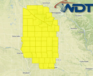
A Severe Thunderstorm Watch is in effect for portions of Iowa, Kansas, Nebraska, and South Dakota until 9pm CDT. Hail to 2" and damaging winds to 65 mph will be …
Read Storyby WeatherOps, on Jun 20, 2014 12:39:26 PM
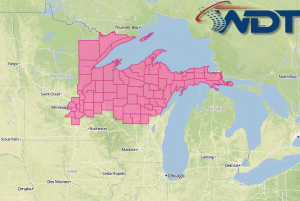
Severe thunderstorms will be possible today for portions of the Central US and Ohio River Valley today. Across Minnesota, a cold front will help provide lift for thunderstorms. To the …
Read Storyby WeatherOps, on Jun 20, 2014 9:45:07 AM

Isolated severe thunderstorms will be possible today for the Upper Midwest and the Southern Plains. General thunderstorms will be possible for portions of the Ohio and Tennessee Valleys. Current NWS …
Read Storyby WeatherOps, on Jun 19, 2014 4:12:48 PM

General thunderstorms will be possible on Friday from portions of the Midwest to the Tennessee Valley. High pressure will build into the Lower Mississippi Valley on Friday as the polar …
Read Storyby WeatherOps, on Jun 19, 2014 12:43:08 PM
Showers and thunderstorms are beginning to develop across the Appalachians in response to daytime heating and plentiful low level moisture. Coverage will increase through the day, with large hail and …
Read Storyby WeatherOps, on Jun 19, 2014 9:40:15 AM
Scattered thunderstorms with isolated severe impacts will be likely today from the Upper Midwest to the Southern Plains; some thunderstorms may be severe. Isolated severe thunderstorms will be possible for …
Read Storyby WeatherOps, on Jun 18, 2014 3:46:06 PM

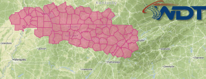
A Severe Thunderstorm Watch is in effect for portions of Western and Central Kansas until 10pm CDT. Hail to 2" and damaging winds to 70 mph will be possible. Watch …
Read Storyby WeatherOps, on Jun 18, 2014 3:22:47 PM
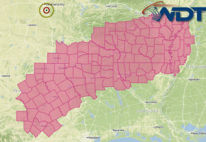
A Severe Thunderstorm Watch is in effect for portions of Oklahoma and Texas until 10pm CDT. Hail to 2" and winds to 70 mph will be possible. Watch Outline …
Read Storyby WeatherOps, on Jun 18, 2014 1:54:05 PM
A Tornado Watch is in effect for portions of North Dakota and South Dakota until 9pm CDT. Hail to 2.5", damaging winds, and tornadoes will be possible. Watch Outline …
Read Storyby WeatherOps, on Jun 18, 2014 1:36:37 PM
A Severe Thunderstorm Watch is in effect for portions of Indiana, Michigan, and Ohio until 9pm EDT. Hail to 1.5" and damaging winds to 70 miles per hour will be …
Read Storyby WeatherOps, on Jun 18, 2014 11:58:00 AM
Severe thunderstorms are likely today across portions of the Plains and Great Lakes ahead of an upper level trough moving into the Northern Plains. As thunderstorms develop, supercells with the …
Read Storyby WeatherOps, on Jun 18, 2014 9:45:14 AM

There will be three areas of concern for severe weather today. The first is from the Dakotas into the Great Lakes. The second from the Eastern Great Lakes into Pennsylvania …
Read Storyby WeatherOps, on Jun 17, 2014 4:31:20 PM
Severe thunderstorms will be possible on Wednesday for the Dakotas into the Great Lakes, the Great Lakes into the Northeast, and Nebraska into the Texas Panhandle. Storms progressing eastward from …
Read Storyby WeatherOps, on Jun 17, 2014 2:43:13 PM
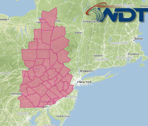
A Severe Thunderstorm Watch is in effect for portions of Western and Central New York until 8pm EDT. Hail to 1.5" and damaging winds to 70 mph will be possible …
Read Storyby WeatherOps, on Jun 17, 2014 1:54:24 PM
A Tornado Watch is in effect for portions of Montana, North Dakota, South Dakota, and Wyoming until 8pm MDT. Large hail to 3", damaging winds to 70 mph, and tornadoes …
Read Storyby WeatherOps, on Jun 17, 2014 12:52:21 PM
Thunderstorms are currently moving across the Great Lakes. While these thunderstorms are not severe, severe thunderstorms are possible later this afternoon as daytime heating continues to destabilize the atmosphere. As …
Read Storyby WeatherOps, on Jun 17, 2014 9:46:48 AM
Severe thunderstorms are possible today for portions of the Northern Rockies into the Northern Plains, as well as the Western Great Lakes. General thunderstorms possible for portions of the Eastern …
Read Storyby WeatherOps, on Jun 16, 2014 4:20:34 PM
Severe thunderstorms are possible Tuesday for portions of South Dakota and the Upper Midwest, as well as portions of Northwestern Texas and Western Oklahoma. Low pressure will deepen over the …
Read Storyby WeatherOps, on Jun 16, 2014 3:31:44 PM
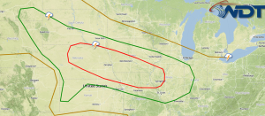
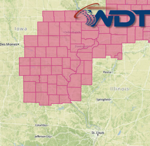
A PDS Tornado Watch is in effect for portions of Iowa and Nebraska until 10pm CDT. Hail to 3", damaging winds to 70 mph, and several tornadoes (with a few …
Read Storyby WeatherOps, on Jun 16, 2014 12:50:24 PM
A Tornado Watch is in effect for portions of Iowa and Minnesota until 8pm CDT. Hail t0 2.5", damaging winds, and tornadoes will be possible. A few tornadoes could be …
Read Storyby WeatherOps, on Jun 16, 2014 12:16:20 PM

Severe thunderstorms are likely today across portions of Nebraska, Iowa, Minnesota, and South Dakota ahead of a shortwave trough moving across the Northern Plains. Large hail and damaging winds will …
Read Storyby WeatherOps, on Jun 16, 2014 9:44:22 AM
Severe thunderstorms are likely today for portions of the Central Plains and Upper Midwest. Further south, isolated severe thunderstorms will be possible for Northwestern Texas and Western Oklahoma. General showers …
Read Storyby WeatherOps, on Jun 13, 2014 3:49:03 PM
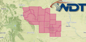
A Severe Thunderstorm Watch is in effect for portions of Montana, North Dakota, and Wyoming until 10pm MDT. Hail to 2.5", damaging winds to 70 mph, and isolated tornadoes will …
Read Storyby WeatherOps, on Jun 13, 2014 2:48:30 PM
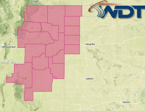
A Severe Thunderstorm Watch is in effect until 9pm MDT for portions of New Mexico. Hail to 2" and damaging winds to 70 mph will be possible. Watch Outline …
Read Storyby WeatherOps, on Jun 13, 2014 12:25:08 PM

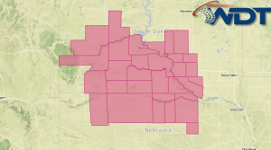
There is a moderate risk for severe weather tomorrow for portions of Iowa, Nebraska, and Kansas. An upper level trough will move into the Plains early tomorrow. Ahead of it, …
Read Storyby WeatherOps, on Jun 13, 2014 9:44:08 AM

Scattered severe thunderstorms are possible today for portions of the Northern Rockies and Plains, as well as along the New Mexico/Texas border. General thunderstorms are possible for portions of the …
Read Storyby WeatherOps, on Jun 12, 2014 4:29:52 PM

Isolated severe thunderstorms will be possible on Friday for portions of the Northern Rockies and Plains; general thunderstorms possible for rest of the Rockies and Plains. Storms will be possible …
Read Storyby WeatherOps, on Jun 12, 2014 2:50:34 PM
Showers and thunderstorms are developing over Central Texas ahead of a cold front. As thnderstorms continue to develop, they will likely become severe, and possibly supercellular, with large hail, damaging …
Read Storyby WeatherOps, on Jun 12, 2014 12:11:03 PM
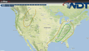
There is a slight risk for severe thunderstorms today across portions of the Southern Plains and the Lower Mississippi Valley. SPC Convective Outlook Remnants from the convection overnight will be …
Read Storyby WeatherOps, on Jun 11, 2014 4:06:58 PM
Showers and thunderstorms will be prevalent along the Eastern Seaboard on Thursday. Severe thunderstorms will be likely across the Arklatex region. A cold front across the Southern Plains will become …
Read Storyby WeatherOps, on Jun 11, 2014 3:36:41 PM
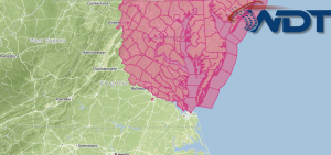
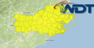
A Severe Thunderstorm Watch is in effect for portions of Maryland, North Carolina, Virginia, and West Virginia until 10pm. Hail to 2" and damaging winds to 70 mph will be …
Read Storyby WeatherOps, on Jun 11, 2014 2:59:51 PM
A Tornado Watch is in effect for portions of Maryland, Pennsylvania, Virginia, and West Virginia until 9pm EDT. Hail to 1.5", damaging winds to 70 mph, and tornadoes will be …
Read Storyby WeatherOps, on Jun 11, 2014 1:24:25 PM
A Severe Thunderstorm Watch is in effect for portions of Virginia and West Virginia until 9pm EDT. Damaging winds to 70 mph and hail to 1" will be possible. Watch …
Read Storyby WeatherOps, on Jun 11, 2014 12:17:03 PM

Thunderstorms are beginning to develop across portions of the Appalachians. As the storms continue to develop, some will likely become severe. Large hail, damaging winds, and tornadoes will be possible …
Read Storyby WeatherOps, on Jun 10, 2014 4:09:33 PM
An area of low pressure over the Plains will begin to weaken as it moves over the Eastern US. Showers and thunderstorms will be possible over the Eastern US on …
Read Storyby WeatherOps, on Jun 10, 2014 2:40:20 PM
A Severe Thunderstorm Watch is in effect until 11pm EDT for portions of Georgia, North Carolina, South Carolina, Tennessee, and Virginia. Damaging winds to 70 mph and hail to 1" …
Read Storyby WeatherOps, on Jun 10, 2014 1:39:59 PM
A Severe Thunderstorm Watch is in effect for portions of Kentucky until 9pm EDT. Hail to 1.5" , damaging winds to 70 miles per hour, and isolated tornadoes will be …
Read Storyby WeatherOps, on Jun 10, 2014 11:13:00 AM
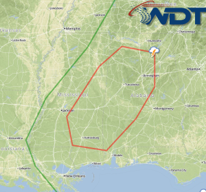
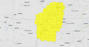
Two new Severe Thunderstorm Watches are in effect. The first is in effect for portions of Northern and Central Alabama, Northwest Georgia, and Middle and Eastern Tennessee until 6pm CDT …
Read Storyby WeatherOps, on Jun 10, 2014 9:41:30 AM
Showers and thunderstorms will develop today across the Tennessee and Lower Mississippi Valleys. Large hail and damaging winds will be possible. Current NWS Advisories/Watches/Warnings A closed low continues across portions …
Read Storyby WeatherOps, on Jun 9, 2014 4:24:21 PM
Scattered thunderstorms will develop from portions of Eastern Texas through Kentucky on Tuesday. A front will extend from Texas into Kentucky. While ongoing convection and cloud cover will limit severe …
Read Storyby WeatherOps, on Jun 9, 2014 3:57:16 PM
A Severe Thunderstorm Watch is in effect for portions of the Carolinas until 11pm EDT. Damaging winds to 1.5" and damaging winds to 70 miles per hour will be possible …
Read Storyby WeatherOps, on Jun 9, 2014 2:33:44 PM
A Tornado Watch is in effect until 7pm CDT for portions of Arkansas, Missouri, Mississippi, and Tennessee. Hail to 1.5", damaging winds to 70 miles per hour, and tornadoes will …
Read Storyby WeatherOps, on Jun 9, 2014 11:52:11 AM
A Severe Thunderstorm Watch is in effect for portions of Arkansas, Louisiana, and Mississippi until 7pm CDT. Damaging winds to 70 miles per hour and hail to 1.5" will be …
Read Storyby WeatherOps, on Jun 9, 2014 9:48:45 AM
Thunderstorms will develop ahead of a cold front on Monday from Texas to the Lower Mississippi Valley; large hail and damaging winds will be possible with these storms. Current NWS …
Read Storyby WeatherOps, on Jun 6, 2014 4:26:51 PM
Thunderstorms capable of large hail and damaging winds will continue on Saturday for portions of the South Central Rockies into the Plains and Missouri Valley. Storms are expected to develop …
Read Storyby WeatherOps, on Jun 6, 2014 4:00:44 PM
A Tornado Watch is in effect for portions of New Mexico, Oklahoma, and Texas until 10pm CDT. Hail to 2", damaging winds to 70 mph, and isolated tornadoes will be …
Read Storyby WeatherOps, on Jun 6, 2014 2:02:56 PM
A Severe Thunderstorm Watch is in effect for portions of Colorado, Nebraska, and South Dakota until 9pm MDT. Hail to 2", damaging winds to 70 mph, and isolated tornadoes will …
Read Storyby WeatherOps, on Jun 6, 2014 12:36:17 PM
Showers and thunderstorms will continue across portions of the Lower Mississippi River Valley and the Southeast tonight along a stationary front. As thunderstorms develop, they will likely become severe with …
Read Storyby WeatherOps, on Jun 6, 2014 9:37:37 AM
Thunderstorms will move through portions of the Rockies, Plains, and South. These storms will have the potential to become severe with large hail, damaging winds, and tornadoes possible. Current NWS …
Read Storyby WeatherOps, on Jun 5, 2014 4:04:36 PM
A Severe Thunderstorm Watch is in effect until 10pm MDT for portions of Colorado and New Mexico. Hail to 2" and damaging winds will be possible. Watch Outline …
Read Storyby WeatherOps, on Jun 5, 2014 2:49:40 PM
A Severe Thunderstorm Watch is in effect until 9pm CDT for portions of Alabama, Georgia, and Tennessee. Hail to 2", damaging winds to 80 mph, and isolated tornadoes will be …
Read Storyby WeatherOps, on Jun 5, 2014 12:54:08 PM
A Severe Thunderstorm Watch is in effect for portions of North Carolina and South Carollina until 9pm EDT. Hail to 1.5" and damaging winds to 70 mph will be possible …
Read Storyby WeatherOps, on Jun 5, 2014 11:27:34 AM
There is a moderate risk of severe weather for today for portions of the Plains and Mid Mississippi River Valley ahead of a shortwave trough. Strong shear across the region …
Read Storyby WeatherOps, on Jun 5, 2014 9:39:01 AM

Severe thunderstorms are likely today across the Plains, Mid Mississippi River Valley and Mid South. Large hail, damaging winds, and tornadoes will be possible. Across the Northeast, showers and thunderstorms …
Read Storyby WeatherOps, on Jun 4, 2014 4:30:38 PM

Severe thunderstorms are possible on Thursday along the east coast and across the Southeast, as well as the Lower Mississippi River Valley and the Plains. The threat for the east …
Read Storyby WeatherOps, on Jun 4, 2014 2:41:15 PM
A Tornado Watch is in effect for portions of Illinois, Indiana, Kentucky, and Missouri until 8pm CDT. Hail to 2", damaging winds to 70 mph, and tornadoes will be possible …
Read Storyby WeatherOps, on Jun 4, 2014 2:04:37 PM
A Tornado Watch is in effect for portions of Indiana, Kentucky, Ohio, Virginia, and West Virginia until 9pm EDT. Tornadoes, hail to 2", and damaging winds to 70 mph possible …
Read Storyby WeatherOps, on Jun 4, 2014 12:39:30 PM
Thunderstorms are developing across the Ohio and Tennessee Valleys. As they continue to develop, some thunderstorms will have the potential to become severe with large hail and damaging winds possible …
Read Storyby WeatherOps, on Jun 4, 2014 9:46:09 AM
Severe thunderstorms will be possible today for portions of the Ohio and Tennessee Valleys; large hail, damaging winds, and tornadoes will be possible. Afternoon and evening thunderstorms will be possible …
Read Storyby WeatherOps, on Jun 3, 2014 4:19:40 PM
Severe thunderstorms will be possible for portions of the Upper Midwest, Ohio River Valley, and Southern Plains on Wednesday. By Wednesday morning, severe weather will be likely across portions of …
Read Storyby WeatherOps, on Jun 3, 2014 3:35:32 PM
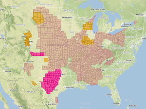
The Storm Prediction Center has issued a high risk of severe weather for portions of the Plains. Large hail greater than 2.5 inches in diameter, widespread damaging winds, and isolated …
Read Storyby WeatherOps, on Jun 3, 2014 1:29:43 PM
A Tornado Watch is in effect until 7pm CDT for portions of Iowa, Missouri, and Nebraska. Large hail to 2.5 inches, damaging winds to 90 mph, and tornadoes will be …
Read Storyby WeatherOps, on Jun 3, 2014 12:18:45 PM
A moderate risk for severe weather continues for portions of the Plains with the threat of large hail, damaging winds, and tornadoes. While the tornado potential will be greatest near …
Read Storyby WeatherOps, on Jun 3, 2014 9:50:52 AM
A Severe Thunderstorm Watch is in effect for portions of Nebraska and South Dakota until 5pm CDT. Hail to 2.5", damaging winds to 70 mph, and isolated tornadoes will be …
Read Storyby WeatherOps, on Jun 3, 2014 9:42:36 AM
Severe thunderstorms with the potential for large hail, damaging winds, and tornadoes will be possible today for portions of the Northern and Central Plains. Current NWS Advisories/Watches/Warnings A warm front …
Read Storyby WeatherOps, on Jun 2, 2014 4:31:28 PM

Scattered showers and severe thunderstorms are possible Tuesday across portions of the Northern Plains and Midwest. SPC Convective Outlook for Tuesday Another upper level trough will exit the Rockies and …
Read Storyby WeatherOps, on Jun 2, 2014 11:58:17 AM
There is a moderate risk for severe weather tomorrow for portions of the Plains. SPC Convective Outlook for Tuesday An upper level trough just off the west coast will move …
Read Storyby WeatherOps, on Jun 2, 2014 9:41:03 AM
Isolated to scattered showers and thunderstorms will be possible Monday across the Northern Plains and Midwest. NWS Advisories/Watches/Warnings in iMapPro An upper level trough will move northeastward across the Northern …
Read Storyby WeatherOps, on May 30, 2014 4:10:24 PM
Isolated severe thunderstorms will be possible Saturday across the Northern and Central Rockies; damaging winds and hail will be possible. For the Rockies, Plains, and Southern US, showers and thunderstorms …
Read Storyby WeatherOps, on May 30, 2014 12:26:57 PM

Showers and thunderstorms are developing across portions of the Southeast in association with an area of low pressure. While no severe weather is expected, heavy rain and some small hail …
Read Storyby WeatherOps, on May 30, 2014 9:45:03 AM
Showers and thunderstorms will be possible today across portions of the Plains and Southeast. Current NWS Advisories/Watches/Warnings in iMapPro: An area of low pressure will continue to lift northward into …
Read Storyby WeatherOps, on May 29, 2014 4:01:42 PM
Showers and thunderstorms will be possible on Friday with isolated severe thunderstorms possible. Hail and damaging winds will be the main threats. General thunderstorms will continue across the Southern Plains …
Read Storyby WeatherOps, on May 29, 2014 12:43:45 PM
Flooding will continue for portions of Louisiana, Mississippi, Florida, and Alabama through tomorrow. Flood Watches Some areas have picked up over 10 inches of rain and could pick up an …
Read Storyby WeatherOps, on May 29, 2014 9:37:31 AM
Thunderstorms will continue on Thursday across the Northern Plains; some thunderstorms may become severe. Showers and thunderstorms will continue for portions of the Southern Plains and Southeast; heavy rain is …
Read Storyby WeatherOps, on May 28, 2014 4:26:34 PM
Thunderstorms will continue across portions of the Northern Plains on Thursday; some may be severe. Showers and thunderstorms will also continue across portions of the Southern Plains and Southeast. Heavy …
Read Storyby WeatherOps, on May 28, 2014 12:19:18 PM
Thunderstorms are currently moving across portions of Louisiana and Mississippi, where a Tornado Watch is currently in effect until 5pm CDT. Damaging winds to 70 mph and tornadoes will be …
Read Storyby WeatherOps, on May 28, 2014 10:26:20 AM
A Tornado Watch is in effect until 5pm CDT for portions of Mississippi and Louisiana until 5pm CDT. Tornadoes and damaging winds to 70 mph will be possible. Watch Outline …
Read Storyby WeatherOps, on May 28, 2014 9:48:21 AM
Severe thunderstorms with the potential for hail, damaging winds, and tornadoes will be possible today across portions of the Northern Plains. Across the Southern Plains and Southeast, showers and thunderstorms …
Read Storyby WeatherOps, on May 23, 2014 4:15:13 PM
Scattered showers and thunderstorms will be possible on Saturday for portions of Southeast New Mexico and Western Texas. Large hail and damaging winds will be possible. A slow moving area …
Read Storyby WeatherOps, on May 23, 2014 2:14:30 PM
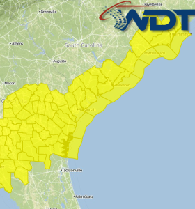
The current Severe Thunderstorm Watch in effect for eastern parts of the Carolinas has been extended to portions of Georgia and western portions of the Carolinas until 9pm EDT. Hail …
Read Storyby WeatherOps, on May 23, 2014 12:26:21 PM
A Severe Thunderstorm Watch is in effect for portions of North Carolina and South Carolina until 9pm EDT. Large hail to 2.5" and damaging winds to 70 mph will be …
Read Storyby WeatherOps, on May 23, 2014 9:51:31 AM
Severe thunderstorms will be possible today for portions of the Central and Eastern US; large hail and damaging winds will be the main threats. Flooding will be possible for portions …
Read Storyby WeatherOps, on May 22, 2014 4:27:55 PM
Scattered severe thunderstorms are possible Friday for portions of Southeast New Mexico into Texas. A strong upper level trough will contribute to supercellular development with the strongest risk extending from …
Read Storyby WeatherOps, on May 22, 2014 2:47:46 PM
A Severe Thunderstorm Watch is in effect for portions of Illinois, Kentucky, Missouri, and Tennessee until 10pm CDT. Hail to 2" and damaging winds to 70 mph will be possible …
Read Storyby WeatherOps, on May 22, 2014 1:42:00 PM
A Severe Thunderstorm Watch is in effect until 10pm EDT for portions of Delaware, Maryland, New Jersey, Virginia, and West Virginia. Hail to 2" and damaging winds to 70 mph …
Read Storyby WeatherOps, on May 22, 2014 1:04:49 PM
A Severe Thunderstorm Watch is in effect for portions of Colorado, New Mexico, Oklahoma, and Texas until 7pm MDT. Damaging winds to 70 mph and large hail will be possible …
Read Storyby WeatherOps, on May 22, 2014 12:56:45 PM
A Severe Thunderstorm Watch has been issued until 8pm EDT for portions of New Jersey, New York, and Pennsylvania. Hail to 2" and damaging winds to 70 mph will be …
Read Storyby WeatherOps, on May 22, 2014 9:44:48 AM
There will be isolated pockets of severe thunderstorms today across portions of the Central and Eastern US. NWS Advisories/Watches/Warnings in iMapPro: The first area with thunderstorm potential will be across …
Read Storyby WeatherOps, on May 21, 2014 4:25:39 PM
Thunderstorms are possible on Thursday for portions of the Central Rockies and Plains. Isolated severe thunderstorms are possible for portions of the Tennessee Valley. A few areas of thunderstorms are …
Read Storyby WeatherOps, on May 21, 2014 3:31:38 PM
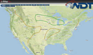
A Severe Thunderstorm Watch is in effect for portions of Southeastern Colorado until 8pm MDT. Hail to 3" and damaging winds to 70 mph possible. Watch Outline …
Read Storyby WeatherOps, on May 21, 2014 2:05:55 PM
A Tornado Watch is in effect for portions of Colorado and Wyoming. Hail to 3 inches, damaging winds to 70 mph, and tornadoes will be possible. Watch Outline …
Read Storyby WeatherOps, on May 21, 2014 1:12:33 PM
A Severe Thunderstorm Watch is in effect for portions of Indiana, Kentucky, Ohio, and West Virginia until 9pm EDT. Large hail to 2.5 inches and damaging winds to 70 mph …
Read Storyby WeatherOps, on May 21, 2014 12:07:51 PM
Thunderstorms are developing across the Ohio River Valley and more development will be likely through the afternoon ahead of a cold front. Radar/Satellite 12:45pm CDT As thunderstorms develop, large hail …
Read Storyby WeatherOps, on May 21, 2014 9:48:11 AM
Thunderstorms will develop today across portions of the Central Appalachians and the Mid Atlantic, with the potential for some isolated severe thunderstorms. Severe thunderstorms will also be possible across portions …
Read Storyby WeatherOps, on May 20, 2014 4:30:53 PM
Thunderstorms will be possible on Wednesday for portions of the Ohio and Missouri Valleys, as well as the Central High Plains. The passing shortwave trough will dip into the Midwest/Ohio …
Read Storyby WeatherOps, on May 20, 2014 3:52:10 PM
A Severe Thunderstorm Watch is in effect until 9pm MDT for portions of Colorado, Nebraska, and Wyoming. Hail to 2", damaging winds to 70 mph, and isolated tornadoes will be …
Read Storyby WeatherOps, on May 20, 2014 9:44:56 AM
Thunderstorms will be possible today across the Southern Great Lakes. Thunderstorms will be possible across the Central and Northern High Plains. Current NWS Advisories/Watches/Warnings: Upslope thunderstorms will be possible across …
Read Storyby WeatherOps, on May 19, 2014 4:30:31 PM
Showers will increase across the Great Basin on Tuesday. Showers and thunderstorms will be possible for portions of the Plains and Great Lakes. Upslope thunderstorms will be possible across Wyoming …
Read Storyby WeatherOps, on May 19, 2014 3:36:13 PM

Newer model data is suggesting the severe weather potential is decreasing across portions of Nebraska. The richer moisture source is across Central Nebraska. With weak low level winds and the …
Read Storyby WeatherOps, on May 19, 2014 12:45:42 PM
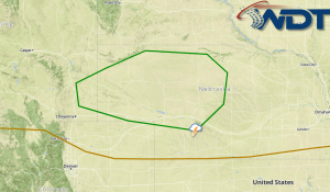
Thunderstorms will be possible for portions of Western and Central Nebraska for this afternoon and evening as a shortwave trough moves over the Rockies and into the Plains. At the …
Read Storyby WeatherOps, on May 19, 2014 9:47:05 AM

Widely scattered showers are possible today across the Pacific Northwest. Isolated thunderstorms will be possible across the Northern High Plains with some severe thunderstorms. Across the Upper Midwest, showers and …
Read Storyby WeatherOps, on May 16, 2014 4:33:29 PM
Showers will continue for portions of Upper New England on Saturday. Isolated showers and thunderstorms will be possible from portions of the Rockies to the Mid South. A cold from …
Read Storyby WeatherOps, on May 16, 2014 9:49:06 AM

Showers will continue across portions of the Northeast today; some areas will have a flooding risk. Isolated showers and thunderstorms will be possible across the Intermountain West and Central Plains …
Read Storyby WeatherOps, on May 15, 2014 4:28:45 PM
Heavy rain is likely on Friday for portions of the Northeast. Showers and thunderstorms will be possible for portions of the Rockies and Plains. The low moving across the Eastern …
Read Storyby WeatherOps, on May 15, 2014 11:27:21 AM
A Severe Thunderstorm Watch is in effect until 8pm EDT for portions of Maryland, North Carolina, Virginia, and West Virginia. Damaging winds to 70 miles per hour and isolated tornadoes …
Read Storyby WeatherOps, on May 15, 2014 9:46:52 AM
Showers and thunderstorms will continue today for the Eastern US with a marginal severe risk for the Central Appalachians to the Eastern Great Lakes. Showers and thunderstorms will be possible …
Read Storyby WeatherOps, on May 14, 2014 4:27:46 PM
Showers and thunderstorms will be possible Thursday from portions of the Southeast to the Great Lakes. Flooding and severe thunderstorms will be possible for portions of the Appalachians to the …
Read Storyby WeatherOps, on May 14, 2014 12:43:07 PM
A Tornado Watch is in effect for portions of Indiana, Kentucky, and Tennessee until 8pm EDT and for portions of Indiania, Kentucky, Ohio, and West Virginia until 9pm EDT. Hail …
Read Storyby WeatherOps, on May 14, 2014 11:50:47 AM
A Severe Thunderstorm Watch is in effect for portions of Northern Alabama, Northeast Mississippi, and Western and Middle Tennessee until 7pm CDT. Damagijng winds to 70 mph, hail to 15", …
Read Storyby WeatherOps, on May 14, 2014 9:48:32 AM
Showers and thunderstorms will be possible today from portions of the Ohio River Valley to the Gulf Coast; there will be the potential for severe thunderstorms and flooding. Current NWS …
Read Storyby WeatherOps, on May 13, 2014 2:01:20 PM
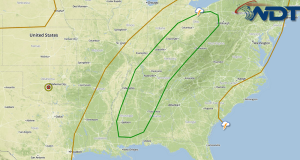
An upper level trough moving across the Plains will bring a chance of severe thunderstorms to portions of the Ohio River Valley and Southeast on Wednesday. At the surface, a …
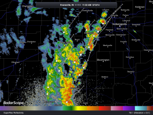
Read Storyby WeatherOps, on May 13, 2014 11:45:59 AM
Thunderstorms are approaching Central Indiana and will affect the cities of Bloomington and Indianapolis. While these thunderstorms are not severe, small hail and gusty winds will be possible with these …
Read Storyby WeatherOps, on May 13, 2014 9:48:07 AM
Showers and thunderstorms will continue today for portions of the East Coast, Midwest, Mid and Lower Mississippi Valley, and the Western Gulf Coast. Flooding will continue for portions of the …
Read Storyby WeatherOps, on May 12, 2014 2:50:17 PM
Showers and thunderstorms will be possible for Tuesday across portions of the East Coast, Midwest, Mid and Lower Mississippi River Valley and into the Western Gulf Coast ahead of a …
Read Storyby WeatherOps, on May 12, 2014 1:17:08 PM
A Severe Thunderstorm Watch is in effect for portions of Iowa, Illinois, and Missouri until 8pm CDT. Large hail to 2", damaging winds to 70 mph, and isolated tornadoes are …
Read Storyby WeatherOps, on May 12, 2014 12:20:50 PM
Thunderstorms are approaching the Milwaukee, WI metro area and will have the potential for heavy rain, strong winds, frequent lightning, and hail. More thunderstorms will develop later this afternoon over …
Read Storyby WeatherOps, on May 12, 2014 10:37:20 AM
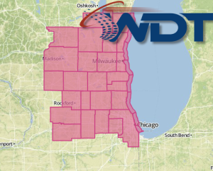
A Severe Thunderstorm Watch is in effect until 5pm CDT for portions of Northern Illinois and Southeastern Wisconsin. Damaging winds to 70 mph and hail to 1.5" will be possible …
Read Storyby WeatherOps, on May 12, 2014 9:45:53 AM
Strong to severe thunderstorms will be possible today for portions of the Upper Great Lakes, Mississippi Valley, and Plains. Showers and general thunderstorms will be possible for the Gulf Coast …
Read Storyby WeatherOps, on May 9, 2014 4:08:26 PM
Showers and thunderstorms will be possible tomorrow from the Southern Plains to the East Coast. Severe thunderstorms will be possible for portions of Missouri into Oklahoma. Showers and isolated thunderstorms …
Read Storyby WeatherOps, on May 9, 2014 1:23:00 PM
A Severe Thunderstorm Watch is in effect for portions of Illinois, Indiana, Kentucky, and Missouri until 8pm CDT. Hail to 2", damaging winds, and isolated tornadoes possible. Watch Outline …
Read Storyby WeatherOps, on May 9, 2014 12:44:10 PM
Severe thunderstorms are likely today across portions of the Plains and Mississippi River Valley ahead of a cold front moving through the Plains. A Severe Thunderstorm Watch is currently in …
Read Storyby WeatherOps, on May 9, 2014 10:57:03 AM
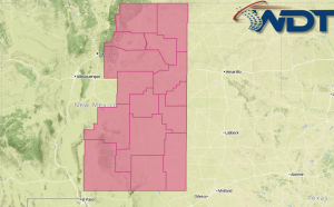
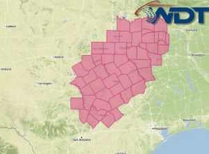
A Severe Thunderstorm Watch is in effect for portions of South Central Texas until 7pm. Hail to 2.5" and damaging winds to 80 mph will be possible. Watch Outline …
Read Storyby WeatherOps, on May 9, 2014 9:49:53 AM
Scattered showers and thunderstorms will be possible today from portions of Texas to the Southern Great Lakes; some thunderstorms may be severe. General showers and thunderstorms will be possible from …
Read Storyby WeatherOps, on May 8, 2014 4:36:13 PM
Scattered showers and thunderstorms with a slight risk for strong to severe thunderstorms will be possible from the Arklatex region into portions of Indiana on Friday. An upper level trough …
Read Storyby WeatherOps, on May 8, 2014 3:53:10 PM
A Severe Thunderstorm Watch is in effect until 10pm for portions of Kansas and Missouri. Hail to 2 inches and damaging winds to 70 mph will be possible. Watch Outline …
Read Storyby WeatherOps, on May 8, 2014 2:25:41 PM
A Severe Thunderstorm Watch is in effect until 9pm CDT for portions of Minnesota and Wisconsin. Hail to 2" and damaging winds will be possible. Watch Outline …
Read Storyby WeatherOps, on May 8, 2014 2:04:03 PM
A Tornado Watch is in effect until 9pm CDT for portions of Iowa, Minnesota, Nebraska, and South Dakota. Hail to 2", damaging winds to 70 mph, and tornadoes will be …
Read Storyby WeatherOps, on May 8, 2014 11:58:50 AM

Thunderstorms are likely today for a large portion of the Plains ahead of an upper level trough moving across the Plains. The risk for thunderstorms extends from Northern Texas into …
Read Storyby WeatherOps, on May 8, 2014 9:53:23 AM
Scattered showers and thunderstorms will be possible for portions of the Plains and Midwest with a slight to moderate risk extending from Northern Texas to Southern Minnesota. Current NWS Advisories/Watches/Warnings …
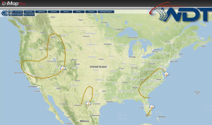
Read Storyby WeatherOps, on May 7, 2014 4:27:14 PM
Scattered showers and isolated severe thunderstorms will be possible Thursday along the Gulf Coast. Across the Midwest and Ohio River Valley, isolated severe thunderstorms will be possible. A shortwave will …
Read Storyby WeatherOps, on May 7, 2014 2:42:40 PM
A Severe Thunderstorm Watch is in effect for portions of Oklahoma and Texas until 10pm CDT. Hail to 2.5", damaging winds to 70 mph, and isolated tornadoes will be possible …
Read Storyby WeatherOps, on May 7, 2014 2:26:13 PM

A Severe Thunderstorm Watch is in effect until 8pm MDT for portions of Colorado, Kansas, Nebraska, and Wyoming. Hail to 2.5", damaging winds to 70 mph, and isolated tornadoes will …
Read Storyby WeatherOps, on May 7, 2014 12:48:22 PM
Severe thunderstorms are possible today across portions of the Plains ahead of an upper level trough moving out of the Rockies. SPC Convective Outlook Thunderstorms will continue to the north …
Read Storyby WeatherOps, on May 7, 2014 9:58:03 AM
Isolated showers and thunderstorms will be possible today for portions of the Plains and Midwest; some thunderstorms may be severe. In the Northern Rockies, heavy rain and snow will be …
Read Storyby WeatherOps, on May 6, 2014 3:05:10 PM
Isolated to scattered showers and isolated severe thunderstorms are possible on Wednesday for portions of the Central Plains and Midwest. Across the Northern Rockies, up to 3 inches of rain …
Read Storyby WeatherOps, on May 6, 2014 9:50:52 AM

Rain and snow showers will continue today for portions of the Northern Rockies and Great Basin. Showers and thunderstorms will be possible for portions of the Central Rockies, Midwest, and …
Read Storyby WeatherOps, on May 5, 2014 4:14:48 PM
Rain and snow showers will be possible for the Northern Rockies and Great Basin on Tuesday. Showers and thunderstorms are possible for portions of the Central Rockies, Midwest, and Mid …
Read Storyby WeatherOps, on May 5, 2014 12:29:50 PM

A large upper level trough will move into the Plains Tuesday night into Wednesday, bringing a potential for severe thunderstorms to portions of the Central and Southern Plains. SPC Convective …
Read Storyby WeatherOps, on May 5, 2014 9:52:04 AM

Isolated showers and afternoon thunderstorms will be possible for portions of the Northern Rockies. Isolated showers and thunderstorms will be possible for portions of the Mid Atlantic. Current NWS Advisories/Watches/Warnings …
Read Storyby WeatherOps, on May 2, 2014 4:32:16 PM
Thunderstorms will be possible on Saturday across Florida, the Great Lakes, and the Pacific Northwest. Showers and thunderstorms will be possible across portions of Central and Southern Florida ahead of …
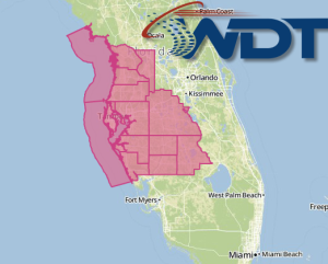
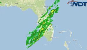
Read Storyby WeatherOps, on May 2, 2014 12:28:16 PM
Thunderstorms are currently moving across portions of Central and Southern Florida ahead of a trailing cold front associated with an area of low pressure that has moved off the East …
Read Storyby WeatherOps, on May 2, 2014 9:50:03 AM
Thunderstorms will be possible today across portions of the Southeast; some isolated severe thunderstorms will be possible, in addition to moderate to heavy rain. Across the Northern High Plains, rain …
Read Storyby WeatherOps, on May 1, 2014 4:31:52 PM
General thunderstorms will be possible tomorrow for portions of the Southeast with isolated severe thunderstorms possible in the afternoon. Moderate to heavy rain will also be possible. Showers will be …
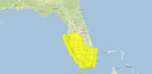
Read Storyby WeatherOps, on May 1, 2014 12:55:57 PM
Thunderstorms currently extend from portions of Southern Georgia into Central Florida. While severe weather is not expected, small hail and damaging winds will be the main concerns. A brief tornado …
Read Storyby WeatherOps, on May 1, 2014 9:53:02 AM

General showers and thunderstorms will be possible today for portions of the Southeast and into the Mid Atlantic. A few thunderstorms in the Mid Atlantic may be severe. Current NWS …
Read Storyby WeatherOps, on Apr 30, 2014 4:29:58 PM
General showers and thunderstorms will be possible for tomorrow across the Southeast and Mid Atlantic; some thunderstorms may be severe. A broad trough will linger across the Eastern US before …
Read Storyby WeatherOps, on Apr 30, 2014 12:31:39 PM
A Tornado Watch is in effect for portions of North Carolina and Virginia until 7pm EDT. Hail to 1", damaging winds to 70 mph, and tornadoes will be possible. Watch …
Read Storyby WeatherOps, on Apr 30, 2014 9:49:41 AM
There is a slight risk for severe weather today for portions of the Southeast and Mid Atlantic. Across the Ohio River Valley, general showers and thunderstorms with a few isolated …
Read Storyby WeatherOps, on Apr 29, 2014 4:46:03 PM
There will be a slight risk for severe thunderstorms on Wednesday for the Mid Atlantic and Southeast. Showers and thunderstorms will be possible for the Ohio River Valley; isolated severe …
Read Storyby WeatherOps, on Apr 29, 2014 2:34:56 PM
A Tornado Watch is in effect for portions of Central and Eastern North Carolina until 9pm EDT. Tornadoes, damaging winds to 70 mph, and hail to 1.5" will be possible …
Read Storyby WeatherOps, on Apr 29, 2014 1:18:18 PM

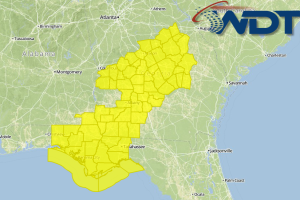
A Tornado Watch is in effect until 9pm CDT for portions of Alabama, Louisiana, and Mississippi. Hail to 2.5", damaging winds t0 70 mph, and several tornadoes are possible. Watch …
Read Storyby WeatherOps, on Apr 29, 2014 11:28:30 AM
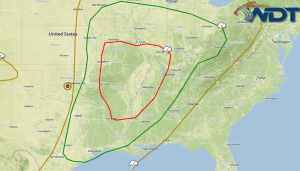
There is a moderate risk for severe weather today for portions of Alabama and Mississippi. Below is the SPC moderate risk outline. SPC Convective Outlook The MCS currently over the …
Read Storyby WeatherOps, on Apr 29, 2014 9:55:26 AM
Severe thunderstorms are likely today across portions of the Southeast. Across the Midwest and Mid Atlantic, general showers and thunderstorms with isolated severe thunderstorms will be possible. Current NWS Advisories/Watches/Warnings …
Read Storyby WeatherOps, on Apr 25, 2014 4:25:08 PM
Severe thunderstorms are possible on Saturday for portions of the Central and Southern Plains. While severe thunderstorms are possible, limited moisture return may limit the severe potential. A few thunderstorms …
Read Storyby WeatherOps, on Apr 25, 2014 1:11:25 PM
A Tornado Watch is in effect for portions of North Carolina and Virginia until 9pm EDT. Hail to 1.5", damaging winds to 70 mph, and tornadoes will be possible. Watch …
Read Storyby WeatherOps, on Apr 25, 2014 12:23:12 PM
Severe thunderstorms with the potential for large hail, damaging winds, and tornadoes will be likely over portions of North Carolina and Virginia. Thunderstorms will increase in coverage through the afternoon …
Read Storyby WeatherOps, on Apr 25, 2014 9:47:14 AM
Isolated severe thunderstorms are possible today for portions of the Mid Atlantic. Rain will continue for portions of the Pacific Northwest and Great Basin. NWS Advisories/Watches/Warnings in iMapPro A trough …
Read Storyby WeatherOps, on Apr 24, 2014 4:16:51 PM
Showers and thunderstorms will be possible on Friday for portions of the Ohio River Valley and Mid Atlantic. In the Pacific Northwest and Great Basin, rain will continue. SPC Convective …
Read Storyby WeatherOps, on Apr 24, 2014 3:07:29 PM

A Severe Thunderstorm Watch is in effect for portions of Arkansas, Louisiana, Missouri, Mississippi, Oklahoma, Tennessee, and Texas until 11pm CDT. Large hail to 2.5", damaging winds, and isolated tornadoes …
Read Storyby WeatherOps, on Apr 24, 2014 2:38:59 PM
A Severe Thunderstorm Watch is in effect for portions of Arkansas, Missouri, and Oklahoma until 10pm CDT tonight. Hail to 2", damaging winds to 70 mph, and isolated tornadoes will …
Read Storyby WeatherOps, on Apr 24, 2014 11:54:05 AM
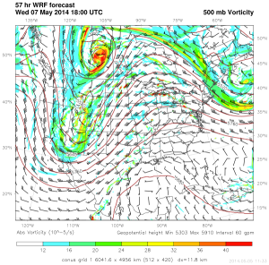
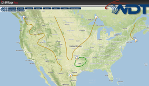
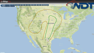
A large upper level system will move across the Central Plains this weekend, bringing the potential for severe weather to much of the Plains both Saturday and Sunday. WDT WRF …
Read Storyby WeatherOps, on Apr 24, 2014 9:46:44 AM
Showers and thunderstorms will be possible Thursday for portions of the Upper Midwest with severe thunderstorms possible for portions of the Mid Mississippi River Valley. Scattered showers are possible for …
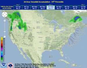
Read Storyby WeatherOps, on Apr 23, 2014 4:32:31 PM
Showers and thunderstorms will be possible on Wednesday for portions of the Upper Midwest and Mid Mississippi River Valley with severe thunderstorms possible for the Lower Mississippi River Valley. Rain …
Read Storyby WeatherOps, on Apr 23, 2014 4:00:19 PM
A Severe Thunderstorm Watch is in effect until 11pm CDT for portions of Kansas, Oklahoma, and Texas. Hail to 3 inches, damaging winds to 75 mph, and isolated tornadoes will …
Read Storyby WeatherOps, on Apr 23, 2014 3:28:28 PM
A Severe Thunderstorm Watch is in effect for portions of Western, Northern, and Central Kansas, as well as Central and East Central Nebraska until 11pm CDT. Damaging winds to 70 …
Read Storyby WeatherOps, on Apr 23, 2014 12:18:41 PM
Thunderstorms are likely today for portions of the High Plains today as an upper level trough moves eastward across the Rockies. Daytime heating ahead of the cold front across the …
Read Storyby WeatherOps, on Apr 23, 2014 9:44:38 AM
Severe thunderstorms are likely today for portions of the Central and Southern Plains. Elsewhere, scattered showers are possible for the Upper Midwest, New England, and Pacific Northwest. Current NWS Advisories/Watches/Warnings …
Read Storyby WeatherOps, on Apr 22, 2014 12:05:47 PM
An upper level trough moving across portions of the Rockies will bring a chance for severe thunderstorms to portions of the Central High Plains on Wednesday. Daytime heating and moisture …
Read Storyby WeatherOps, on Apr 22, 2014 9:48:17 AM
Showers and thunderstorms will continue today for portions of the Southeast. Tonight, some thunderstorms will be likely for portions of the High Plains. Scattered showers will be possible for portions …
Read Storyby WeatherOps, on Apr 21, 2014 4:31:34 PM
Showers and thunderstorms will be possible for portions of the Southeast and Mid Atlantic on Tuesday. Rain and mountain snow will be possible for the Pacific Northwest and into the …
Read Storyby WeatherOps, on Apr 21, 2014 3:06:19 PM
A Severe Thunderstorm Watch is in effect for portions of Central, North Central, and Northeast Texas until 10pm CDT. Hail to 2" and damaging winds to 70 mph will be …
Read Storyby WeatherOps, on Apr 21, 2014 12:38:57 PM
There is a slight risk of severe weather for portions of the Plains today ahead of a stalled front. This area extends from portions of Southwestern Texas into the Arklatex …
Read Storyby WeatherOps, on Apr 21, 2014 9:47:32 AM
Showers and thunderstorms will be possible today from portions of the Southern Plains and Midwest. There is a slight risk for severe thunderstorms for portions of Central and Northeastern Texas …
Read Storyby WeatherOps, on Apr 18, 2014 4:19:32 PM
Scattered showers and thunderstorms are possible Saturday from the Four Corners region into the Central Plains. Across the coastal areas of the Southeast, showers and thunderstorms will be possible. An …
Read Storyby WeatherOps, on Apr 18, 2014 1:13:47 PM
A Severe Thunderstorm Watch is in effect for portions of West Central Florida until 8pm EDT. Damaging winds to 70 mph will be the main concerns with these storms. Watch …
Read Storyby WeatherOps, on Apr 18, 2014 12:42:27 PM

Thunderstorms are approaching the Florida peninsula and will continue through the afternoon. Heavy rain will be the main threat with these storms, but some isolated damaging winds will also be …
Read Storyby WeatherOps, on Apr 18, 2014 9:38:07 AM
Showers and thunderstorms, some severe, are possible for portions of Florida today. Isolated showers and thunderstorms are possible over the Western US. Across the Upper Midwest, moderate snow and light …
Read Storyby WeatherOps, on Apr 17, 2014 4:30:40 PM

Showers and thunderstorms are possible on Friday for portions of Florida. A few isolated showers and thunderstorms will be possible for portions of the Western US. By Friday morning, showers …
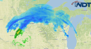
Read Storyby WeatherOps, on Apr 17, 2014 12:49:22 PM
Snow will continue for portions of the Northern Great Lakes through the afternoon. Less than an inch of additional snow is expected. Radar image Snowfall accumulation through 4pm CDT …
Read Storyby WeatherOps, on Apr 17, 2014 9:48:47 AM
Showers, and possibly some thunderstorms, will be possible today for portions of the Central and Southern Plains. A few severe thunderstorms will be possible across the Gulf Coast. Showers and …
Read Storyby WeatherOps, on Apr 16, 2014 4:30:51 PM
Showers and possibly some thunderstorms will be possible for portions of the Central and Southern Plains. Showers and thunderstorms will also be possible for portions of the Gulf Coast and …
Read Storyby WeatherOps, on Apr 16, 2014 12:30:24 PM
Heavy snow is continuing to move across portions of Minnesota and Wisconsin ahead of an area of low pressure over the Central Plains. Up to a foot of snow will …
Read Storyby WeatherOps, on Apr 16, 2014 9:48:38 AM
Moderate to heavy snow will continue through the day for portions of the Northern Plains and Upper Midwest. Across the Central Rockies, a light to moderate snow mix can be …
Read Storyby WeatherOps, on Apr 15, 2014 3:25:43 PM
Light to moderate snow will be possible for portions of the Northern Plains and Upper Midwest on Wednesday. A rain/snow mix will be possible across the Central Rockies. WDT preferred …
Read Storyby WeatherOps, on Apr 15, 2014 10:07:51 AM
Showers and thunderstorms will continue for portions of the Northeast, with some flash flooding possible. Across the Eastern Great Lakes and Northern New England, moderate snow and light icing will …
Read Storyby WeatherOps, on Apr 14, 2014 4:29:00 PM

Scattered showers will be possible across the Eastern US with isolated severe thunderstorms possible for the coastal areas of the Carolinas and Virginia. 3-6 inches will be possible for portions …
Read Storyby WeatherOps, on Apr 14, 2014 1:51:19 PM

A Severe Thunderstorm Watch is in effect for portions of Louisiana, Mississippi, and Texas until 9pm CDT. Large hail to 2" and damaging winds to 70 miles per hour will …
Read Storyby WeatherOps, on Apr 14, 2014 12:18:07 PM
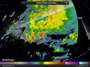
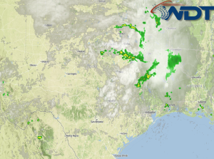
Severe thunderstorms have developed in Southeastern Texas. Radar has indicated the potential for hail as big as 3 inches. In addition to the hail, damaging winds and lightning will be …
Read Storyby WeatherOps, on Apr 14, 2014 11:01:08 AM

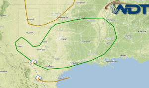
Severe Thunderstorm Watch in effect for portions of Northern Louisiana and Central and Eastern Texas until 5pm CDT. Hail to 2" and damaging winds to 70 mph will be possible …
Read Storyby WeatherOps, on Apr 14, 2014 9:47:43 AM
Isolated severe thunderstorms are possible today for portions of the Arklatex region, Lower Mississippi River Valley, and the Gulf Coast. A rain and snow mix is likely for portions of …
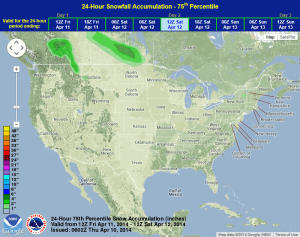
Read Storyby WeatherOps, on Apr 11, 2014 4:28:36 PM

Severe thunderstorms are possible Saturday for portions of the Central Plains and Upper Midwest. Light to moderate snow will be possible for portions of the Northern Rockies and Intermountain West …
Read Storyby WeatherOps, on Apr 11, 2014 9:40:37 AM
Scattered showers and thunderstorms will be possible today for portions of the Ohio River Valley, Mid Atlantic, and Northeast. In the west, showers and thunderstorms will be possible for portions …
Read Storyby WeatherOps, on Apr 10, 2014 4:29:47 PM
Scattered showers and isolated thunderstorms will be possible Friday across portions of the Ohio River Valley and Northeast. Across the Northern Rockies, light snow will be possible for the higher …
Read Storyby WeatherOps, on Apr 10, 2014 9:18:13 AM
Isolated showers and thunderstorms will be possible today for portions of the Northern Plains and Midwest. An area of low pressure over the Northern Plains will continue to move southeast …
Read Storyby WeatherOps, on Apr 9, 2014 4:17:53 PM
Isolated showers and thunderstorms will be likely across portions of the Northern Plains and Midwest on Thursday ahead of an area of low pressure. The main threats will be isolated …
Read Storyby WeatherOps, on Apr 9, 2014 9:33:30 AM
Isolated showers and thunderstorms will be possible today across the Northern Rockies and Northern Plains. Current NWS Advisories/Watches/Warnings in iMapPro Calm conditions will continue for much of the country as …
Read Storyby WeatherOps, on Apr 8, 2014 4:27:46 PM
Isolated showers and thunderstorms are possible tomorrow for portions of the Northern Plains as an area of low pressure moves into the Northern Plains. Severe weather is not anticipated, but …
Read Storyby WeatherOps, on Apr 8, 2014 12:44:37 PM
Showers and thunderstorms will continue across portions of Central and Southern Florida ahead of a cold front. While no severe weather is anticipated, damaging winds and hail will be the …
Read Storyby WeatherOps, on Apr 8, 2014 9:26:15 AM

Isolated showers and thunderstorms are possible today for portions of the eastern US. Some showers and thunderstorms will linger across Florida. Current NWS Advisories/Watches/Warnings in iMapPro An area of low …
Read Storyby WeatherOps, on Apr 7, 2014 4:32:08 PM

Showers and thunderstorms will be possible tomorrow for portions of the Lower Mississippi Valley and Southeast. A frontal boundary will continue to progress off the East coast with rain and …
Read Storyby WeatherOps, on Apr 7, 2014 1:46:52 PM
A Tornado Watch is in effect for portions of Northeast Florida, Eastern Georgia, Southeast North Carolina, and Eastern South Carolina. Several tornadoes and damaging wind gusts to 70 mph are …
Read Storyby WeatherOps, on Apr 7, 2014 12:24:05 PM
A Tornado Watch is in effect until 4pm EDT for portions of Alabama, Florida, and Georgia. Watch Outline Tornadoes and damaging wind gusts to 70 mph will be possible. As …
Read Storyby WeatherOps, on Apr 7, 2014 9:41:25 AM

There will be a slight risk for severe thunderstorms for portions of Georgia, North Carolina, and South Carolina with the potential for hail, damaging winds, and tornadoes today. Across portions …
Read Storyby WeatherOps, on Apr 4, 2014 4:20:34 PM

Light to moderate snow and some light icing will be possible on Saturday for portions of Northern Maine. Thunderstorms are also likely from the Southern Plains into the Southeast. The …
Read Storyby WeatherOps, on Apr 4, 2014 12:54:37 PM
Snow will continue to fall across portions of the Great Lakes. 3-6 inches of snow, in addition to hazardous travel conditions and low visibilities are possible for portions of Minnesota, …
Read Storyby WeatherOps, on Apr 4, 2014 9:45:24 AM

Severe thunderstorms will continue through early afternoon for portions of the Ohio River Valley and south to the Gulf Coast. Across the Northern Great Lakes, moderate to heavy snow will …
Read Storyby WeatherOps, on Apr 3, 2014 4:31:06 PM
Severe thunderstorms will be possible tomorrow for portions of the Upper Ohio River Valley down to the Gulf Coast. Across the Upper Northeast, snow and light ice will be possible …
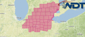
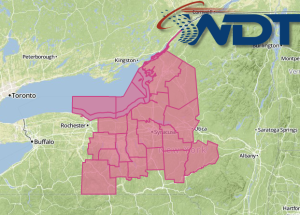
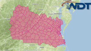
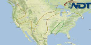
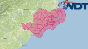
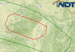
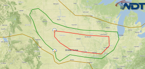
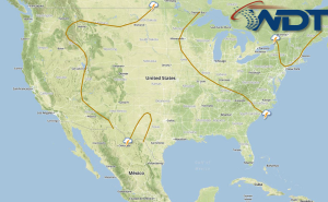
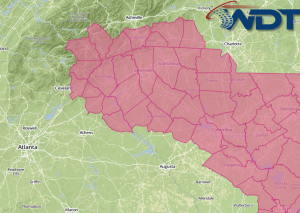
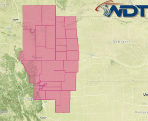
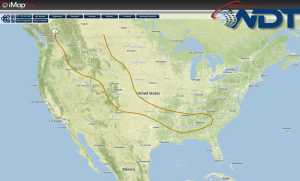
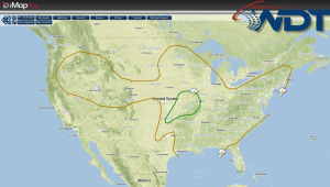
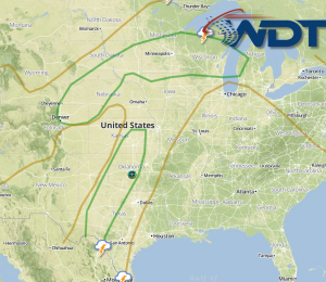
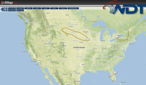
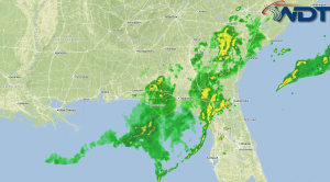
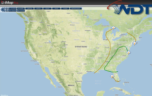
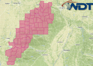
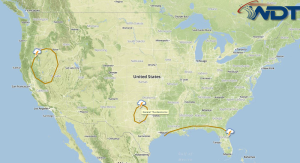
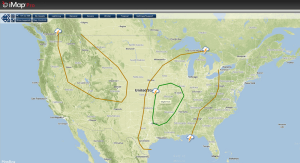
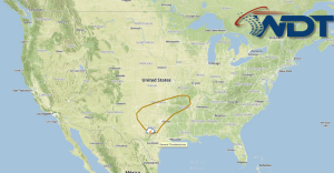
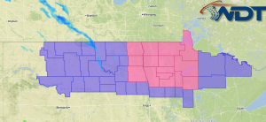
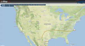
Read Storyby Daphne Thompson, on Apr 3, 2014 4:17:05 PM
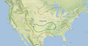
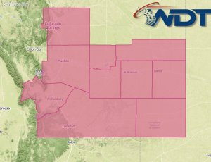
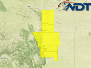
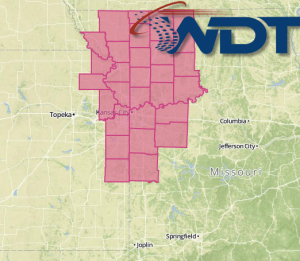
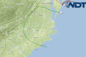
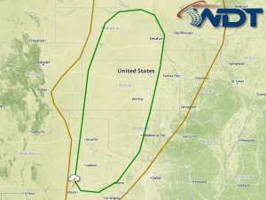
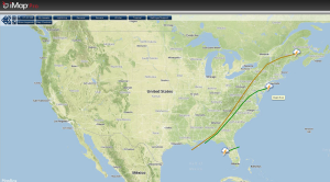
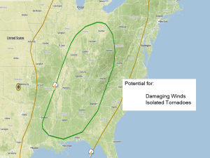
Our team of meteorologists have hand drawn the path of the tornado and damaging winds of this morning's tornadic acitivty near St. Louis. The path is based on radar data, …
Read Storyby WeatherOps, on Apr 3, 2014 12:53:56 PM
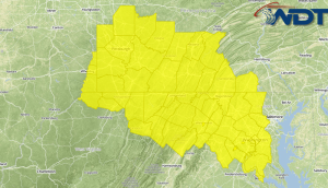
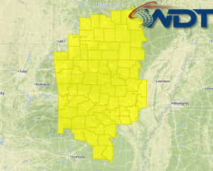
There is a moderate risk of severe weather today for portions of the Mississippi River Valley, with the main concern for much of Missouri and Arkansas. Hail to 3", damaging …
Read Storyby WeatherOps, on Apr 3, 2014 11:02:19 AM
A Tornado Watch is in effect until 5pm CDT for portions of Arkansas and Missouri until 5pm CDT. Several tornadoes (with the potential for intense tornadoes), hail to 3", and …
Read Storyby WeatherOps, on Apr 3, 2014 9:28:43 AM
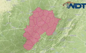
Severe thunderstorms with the potential for very large hail, damaging winds, and tornadoes are likely today for portions of Eastern Texas, Oklahoma, and Kansas through Tennessee, Kentucky, and Ohio. Moderate …
Read Storyby WeatherOps, on Apr 2, 2014 4:34:24 PM
Severe thunderstorms are likely tomorrow for portions of the Central Plains, Missouri Valley, and Southern US. Large hail, damaging winds, and tornadoes are possible from portions of Texas and northeastward …
Read Storyby WeatherOps, on Apr 2, 2014 2:57:20 PM
A Tornado Watch has been issued for portions of Kansas, Missouri, and Oklahoma until 10pm CDT. Hail to 3 inches in diameter, damaging winds to 70 mph, and tornadoes will …
Read Storyby WeatherOps, on Apr 2, 2014 12:53:47 PM
There is a slight risk for severe weather today across portions of the Plains in association with a stationary front across portions of Oklahoma, Kansas, and Missouri. Storms will develop …
Read Storyby WeatherOps, on Apr 1, 2014 12:35:57 PM
There is a slight risk for severe weather this afternoon and evening across the Plains ahead of a dryline in West Texas. Convergence ahead of the dryline will allow for …
Read Storyby WeatherOps, on Apr 1, 2014 9:19:58 AM
A few isolated storms will be possible today across portions of Eastern Kansas and portions of Southwestern Oklahoma/Northwestern Texas. Mountain snow will be possible for portions of portions of the …
Read Storyby WeatherOps, on Mar 31, 2014 4:30:57 PM
A few thunderstorms will be possible for portions of Eastern Kansas, Southwestern Oklahoma and Northwestern Texas on Tuesday. Some of these storms will have the potential to become severe. Mountain …
Read Storyby WeatherOps, on Mar 31, 2014 12:39:07 PM
There is a slight risk for severe thunderstorms tomorrow across portions of the Central and Southern Plains as a lee cyclone develops across the region. Ahead of this system, daytime …
Read Storyby WeatherOps, on Mar 31, 2014 9:31:23 AM
Moderate to heavy snow will continue throughout the day from South Dakota into Northern Minnesota. For the Sierra Nevada, moderate to heavy snow will be possible. Showers and thunderstorms will …
Read Storyby WeatherOps, on Mar 28, 2014 4:01:22 PM
Rain and thunderstorms will continue for the Southeast on Saturday with a slight risk of severe weather from Northern Florida into the Carolinas and SE Virginia. Low elevation rain and …
Read Storyby WeatherOps, on Mar 28, 2014 3:06:51 PM
A Severe Thunderstorm Watch has been issued for portions of Arkansas, Louisiana, Mississippi, Oklahoma, and Texas until 10pm CDT. Hail to 2", damaging winds to 70 mph, and a few …
Read Storyby WeatherOps, on Mar 28, 2014 1:22:23 PM
A Severe Thunderstorm Watch is in effect for portions of Central and Northeast Texas until 7pm CDT. Hail to 3", damaging winds, and tornadoes will be possible. Watch Outline …
Read Storyby WeatherOps, on Mar 28, 2014 12:21:14 PM
Thunderstorms are moving across the Florida Panhandle this afternoon. As these storms continue to move east, damaging winds will be the main concern. Latest Radar Thunderstorms will also be possible …
Read Storyby WeatherOps, on Mar 28, 2014 9:44:24 AM
Scattered showers and thunderstorms will be possible today for the Great Lakes and Northeast. Showers and thunderstorms will be possible for the Southeast, some of which may become severe. Showers …
Read Storyby WeatherOps, on Mar 27, 2014 4:35:11 PM
Rain and thunderstorms will be possible for portions of the Southeast on Friday. There is a slight risk for severe weather from Eastern Texas into the Lower Mississippi River Valley …
Read Storyby WeatherOps, on Mar 27, 2014 1:11:45 PM
A Tornado Watch is in effect for portions of Kansas, Missouri, and Oklahoma until 8pm CDT tonight. Hail to 1.5", damaging winds to 70 miles per hour, and tornadoes will …
Read Storyby WeatherOps, on Mar 27, 2014 11:57:51 AM

Thunderstorms are developing across portions of the Southern Plains today ahead of a dryline across portions of Oklahoma. To the north, an area of low pressure will develop over portions …
Read Storyby WeatherOps, on Mar 27, 2014 9:40:48 AM
Moderate to heavy snow and light icing is possible today for portions of the Great Lakes. Showers and thunderstorms will be possible for portions of the Southern Plains and Central …
Read Storyby WeatherOps, on Mar 26, 2014 4:15:22 PM
Moderate to heavy snow and light icing will be possible for portions of the Great Lakes tomorrow. Showers and thunderstorms will also be possible for portions of the Southern Plains …
Read Storyby WeatherOps, on Mar 26, 2014 12:49:07 PM
Blizzard conditions will continue for coastal areas of New England as an area of low pressure off the coast continues to move northeast. Winds to 60 mph and snow totals …
Read Storyby WeatherOps, on Mar 26, 2014 9:35:34 AM
Moderate to heavy snow, in addition to strong winds, will be likely for the coastal areas of New England and the Northeast; blizzard conditions will be possible. Showers and thunderstorms …
Read Storyby WeatherOps, on Mar 25, 2014 4:24:07 PM
Moderate to heavy snow is possible on Wednesday for coastal areas of the Northeast and New England regions with blizzard conditions possible. Showers and thunderstorms will also be possible for …
Read Storyby WeatherOps, on Mar 25, 2014 12:44:40 PM
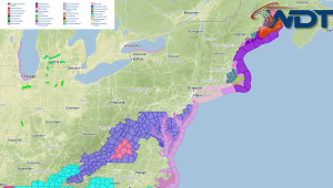
A winter storm will impact the Northeast on Wednesday as an area of low pressure moves northward along the East Coast. Current NWS Advisories Along with heavy snow, accumulations to …
Read Storyby WeatherOps, on Mar 25, 2014 9:36:19 AM
Light to moderate snow, in addition to increasing winds will be possible today from the Central Appalachians to the Coastal New England areas. Showers and storms will be possible along …
Read Storyby WeatherOps, on Mar 24, 2014 4:33:39 PM
Light to moderate snow will be possible tomorrow across the Midwest and Great Lakes. Showers and thunderstorms will be possible for portions of the Southeast, with the potential for heavy …
Read Storyby WeatherOps, on Mar 24, 2014 2:20:42 PM
A system developing over the Gulf of Mexico will become the focal point for an intense winter storm across the Northeast on Wednesday. This system will move across the Florida …
Read Storyby WeatherOps, on Mar 24, 2014 9:29:57 AM
A rain/snow mix and light snow is likely today for portions of the Northern Plains and Midwest. For portions of the Gulf Coast and into Florida, showers and thunderstorms will …
Read Storyby WeatherOps, on Mar 21, 2014 4:12:08 PM
Light to moderate snow will continue for portions of the Northern New England region. Moderate snow will continue for the Central Rockies. Thunderstorms will be possible for portions of the …
Read Storyby WeatherOps, on Mar 21, 2014 12:58:16 PM
Blizzard conditions are possible for portions of North Dakota and Minnesota through early evening. This is a look at the current advisories. Current NWS Advisories in iMapPro Wind gusts to …
Read Storyby WeatherOps, on Mar 21, 2014 9:42:06 AM
Light to moderate snow will fall across the Northern Plains and Upper Great Lakes, as well as the Central and Northern Rockies, today. Severe thunderstorms will also be possible for …
Read Storyby WeatherOps, on Mar 20, 2014 4:31:14 PM
Light to moderate snow is possible on Friday for portions of the Northern Plains into the Great Lakes, as well as portions of the Rockies. A marginal severe thunderstorm potential …
Read Storyby WeatherOps, on Mar 20, 2014 12:38:37 PM
Snow is likely tonight and into Friday for portions of the Northern Plains ahead of an upper level system across the Northern Rockies and Southern Canada. Current NWS Advisories/Watches/Warnings 4-6 …
Read Storyby WeatherOps, on Mar 20, 2014 9:40:29 AM
Light rain and snow, as well as some lake effect snow , will linger across the Northeast. Light snow will also be possible for portions of the Intermountain West and …
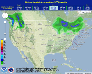
Read Storyby WeatherOps, on Mar 19, 2014 4:03:10 PM
Light snow and some lake effect snow will be possible on Thursday for portions of the Northeast. Light to moderate snow will be possible for portions of the Intermountain West …
Read Storyby WeatherOps, on Mar 19, 2014 12:37:09 PM
Precipitation will continue across portions of the Great Lakes ahead of an area of low pressure. Snow, sleet, and freezing rain will be possible through tonight. No significant accumulations expected …
Read Storyby WeatherOps, on Mar 19, 2014 9:40:47 AM

Showers and thunderstorms will be possible for portions of the Midwest and Great Lakes today, changing over to a rain/snow mix tonight. Rain and snow will develop for portions of …
Read Storyby WeatherOps, on Mar 18, 2014 4:33:00 PM
Light to moderate snow is likely on Wednesday for the Upper Mississippi River Valley. Further east, a light rain/snow mix is possible for portions of the Great Lakes with rain …
Read Storyby WeatherOps, on Mar 18, 2014 12:48:48 PM
Snow will continue through the day across the Northern Plains to the north of a stationary front. Current NWS Advisories/Watches/Warnings in iMapPro: 2-4 inches of additional snow will be possible …
Read Storyby WeatherOps, on Mar 18, 2014 9:40:13 AM
Moderate to heavy snow will be possible today for portions of the Central Plains and the Upper Mississippi River Valley. For the Southern Great Lakes and Upper Midwest, showers and …
Read Storyby WeatherOps, on Mar 17, 2014 4:35:18 PM
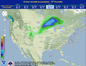
Light icing will be possible for Tuesday across portions of West Virginia, Virginia, and North Carolina. Light to moderate snow is possible for portions of the Northern Plains and Great …
Read Storyby WeatherOps, on Mar 17, 2014 12:05:38 PM

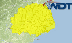
A Tornado Watch is in effect for portions of Central and Southern Florida until 11pm EDT. Current watch outline in iMapPro Several tornadoes, with a few intense tornadoes, and damaging …
Read Storyby WeatherOps, on Mar 17, 2014 9:39:46 AM
Light to moderate snow will end across the Mid Atlantic by midday. Across Florida, isolated severe thunderstorms will be possible through the afternoon. For the Northern Rockies and the Northern …
Read Storyby WeatherOps, on Mar 14, 2014 4:10:09 PM

Light snow will continue for portions of the Northern Plains and Midwest on Saturday. Across the Southern Plains, showers and severe thunderstorms will be possible for portions of the Southern …
Read Storyby WeatherOps, on Mar 14, 2014 12:36:43 PM
There is a slight risk for severe weather for portions of the Southern Plains on Saturday ahead of an upper level trough. SPC Convective Outlook for Saturday Thunderstorms should develop …
Read Storyby WeatherOps, on Mar 14, 2014 9:45:17 AM
Light snow will be possible today for Northern New England. In the Desert Southwest and Southern Plains, showers and thunderstorms will be possible. Light to moderate snow will also be …
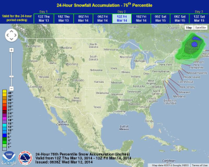
Read Storyby WeatherOps, on Mar 13, 2014 4:44:48 PM
On Friday, light snow will be possible for northern portions of New England. Showers and thunderstorms will be possible for the Desert Southwest and Southern Plains. Light to moderate snow …
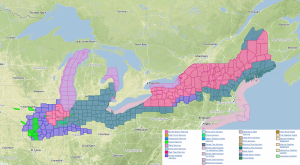
Read Storyby WeatherOps, on Mar 13, 2014 12:47:16 PM
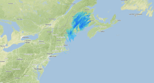
Snow is ending across the Northeast as a front moves offshore. Snow totals could be as high as two feet in some areas. Latest Radar Another 2 inches of snow …
Read Storyby WeatherOps, on Mar 13, 2014 9:50:24 AM

Light to moderate snow will be possible today for Northern Maine and the Mid Atlantic. In addition, the wildfire danger will remain high in these areas. Across the Central and …
Read Storyby WeatherOps, on Mar 12, 2014 4:13:19 PM
Light to moderate snow will continue for portions of Maine on Thursday ahead of a front lifting through the Northwest. Accumulations will remain under 4 inches. Showers and thunderstorms will …
Read Storyby WeatherOps, on Mar 12, 2014 9:41:44 AM
Moderate to heavy snow, as well as light icing, will continue for portions of the Great Lakes to the Northeast. Windy conditions will lead to reduced visibilities. For the Southeast …
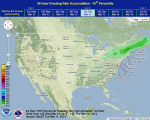
Read Storyby WeatherOps, on Mar 11, 2014 4:17:28 PM
Moderate to heavy snow will be possible for portions of the Great Lakes and Northeast on Wednesday. Showers and thunderstorms will continue for portions of the Mid Atlantic and Southeast …
Read Storyby WeatherOps, on Mar 11, 2014 11:50:08 AM
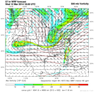
A winter storm will bear down on portions of the Great Lakes and Northeast as an upper level system moves across the Plains. Current NWS Advisories/Watches/Warnings An upper level system …
Read Storyby WeatherOps, on Mar 11, 2014 9:36:38 AM

Light to moderate snowfall will be possible today from the Central Rockies through the Southern Great Lakes. Showers and thunderstorms will be possible for portions of the Central Plains and …
Read Storyby WeatherOps, on Mar 10, 2014 4:16:39 PM
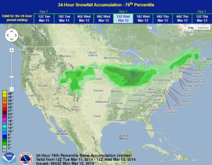
A cold front and area of low pressure will move through the Central and Southern Plains on Tuesday with a large swath of precipitation from the Central Rockies through the …
Read Storyby WeatherOps, on Mar 10, 2014 12:13:51 PM
There will be the potential for significant winter weather across portions of the Great Lakes and Northeast ahead of an upper level system. Heavy snow with accumulations of 5-10 inches …
Read Storyby WeatherOps, on Mar 10, 2014 9:42:17 AM
Snow will continue in the higher elevations of the Northern Rockies, but rain will continue for the lower elevations. Across the Northeast, light snow will be possible for the northern …
Read Storyby WeatherOps, on Mar 6, 2014 4:28:06 PM

Light to moderate snow will move into portions of Nebraska on Friday. A light moderate wintry mix is possible for portions of the Southern Appalachians, but scattered showers and thunderstorms …
Read Storyby WeatherOps, on Mar 6, 2014 11:13:39 AM
A Tornado Watch is in effect for portions of Central and Southern Florida until 7pm EST. In addition to tornadoes, damaging winds to 70 mph and hail to 1" will …
Read Storyby WeatherOps, on Mar 6, 2014 9:43:24 AM
Scattered showers and thunderstorms will be possible today across the Southeast with severe thunderstorms across Florida. Showers will also be possible along the Pacific Northwest coastline with moderate snow across …
Read Storyby WeatherOps, on Mar 5, 2014 4:18:16 PM

Light to moderate snow is possible for portions of the Northern High Plains and Upper Midwest ahead of a low amplitude trough. 1-3 inches will be possible from Montana into …
Read Storyby WeatherOps, on Mar 5, 2014 11:44:23 AM
Today marked the 45th day this winter of measurable snow in Chicago. This is a record for the number of snow days through March 5 in 129 years of snow …
Read Storyby WeatherOps, on Mar 5, 2014 9:43:20 AM

Scattered showers and thunderstorms will continue for portions of the Gulf Coast. Light to moderate snow will be possible for portions of Wisconsin, Illinois, Michigan, and Indiana. A light rain/snow …
Read Storyby WeatherOps, on Mar 4, 2014 4:03:47 PM

Light snow will continue for portions of the Central Plains and Midwest on Wednesday. Across the Southeast, moderate to heavy showers and light freezing rain will be possible across portions …
Read Storyby WeatherOps, on Mar 4, 2014 11:47:45 AM
Travel was dangerous Tuesday morning as freezing rain and sleet caused traffic accidents across the Houston area. In addition to the traffic problems, power outages were also being reported. As …
Read Storyby WeatherOps, on Mar 4, 2014 9:48:58 AM

Sleet and freezing rain along the Texas/Louisiana coasts will transition to rain this afternoon. General thunderstorms will be possible through this afternoon. Across the Northern Plains, light snow will be …
Read Storyby WeatherOps, on Mar 3, 2014 4:15:47 PM
Light snow will be possible for portions of the Northern Plains on Tuesday. Moderate to heavy showers with light freezing rain possible in the morning across portions of Texas and …
Read Storyby WeatherOps, on Mar 3, 2014 12:01:12 PM
Officials in Tennessee have warned motorists about icy roads across the state and the governor has declared a state of emergency due to deteriorating conditions. Officials have reported that several …
Read Storyby WeatherOps, on Mar 3, 2014 9:35:06 AM

Showers will transition to a wintry mix for portions of the Mid Atlantic this morning before transitioning to all snow by this afternoon. Scattered showers will be possible ahead of …
Read Storyby WeatherOps, on Feb 28, 2014 3:59:40 PM
A strong area of low pressure across the Western US will allow for heavy rain and mountain snows across portions of California and the Rockies on Saturday. A surface front …
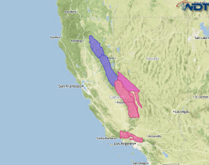
Read Storyby WeatherOps, on Feb 28, 2014 3:02:07 PM
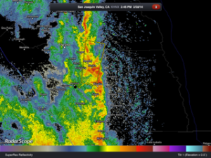
Severe thunderstorms have developed across Central California ahead of an area of low pressure. This is a recent radar image. Quarter sized hail and damaging wind gusts to 70 mph …
Read Storyby WeatherOps, on Feb 28, 2014 12:06:14 PM

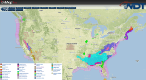
Drought stricken California will receive some well needed rain over the next few days thanks to two storm systems. Infrared Satellite from iMapPro Over two inches of rain have already …
Read Storyby WeatherOps, on Feb 28, 2014 9:35:28 AM
Heavy rain will continue for the valleys of California and the Rockies with moderate to heavy snow for the higher elevations today. Across the Great Lakes and Midwest, light to …
Read Storyby WeatherOps, on Feb 27, 2014 4:27:17 PM
Showers and thunderstorms will continue for the lower elevations of California and into the Rockies with moderate to heavy snow for the higher elevations. Light to moderate snow will also …
Read Storyby WeatherOps, on Feb 27, 2014 3:11:55 PM
Heavy rain will continue for Northern California as several storm systems continue to move into the region. Storm Total Precipitation for Northern California Two more systems are continuing to move …
Read Storyby WeatherOps, on Feb 27, 2014 12:36:15 PM
Heavy snow will continue for portions of Northern California through Saturday night. Below is a look at the advisories currently in effect. A series of low pressure systems will bring …
Read Storyby WeatherOps, on Feb 27, 2014 9:36:46 AM
Valley showers and isolated thunderstorms will continue today for portions of the lower elevations of California into the Rockies, with moderate to heavy snow in the higher elevations. Light lake …
Read Storyby WeatherOps, on Feb 26, 2014 3:53:11 PM
Showers and isolated thunderstorms will be possible on Thursday for the lower elevations of California and into the Rockies, as well as moderate to heavy snow for the higher elevations …
Read Storyby WeatherOps, on Feb 26, 2014 11:32:43 AM
A Blizzard Warning is in effect for portions of Central and Southern Minnesota until 3am tomorrow morning. Blizzard Warning in iMapPro Very strong winds will occur through the day as …
Read Storyby WeatherOps, on Feb 26, 2014 9:33:26 AM
Lake effect snow is expected today for portions of the Great Lakes. In California, showers and isolated thunderstorms will be possible in the lower elevations with moderate to heavy snow …
Read Storyby WeatherOps, on Feb 25, 2014 4:15:42 PM
Lake effect snow is expected tomorrow for portions of the Great Lakes on Wednesday. In portions of California, showers and thunderstorms will be possible for the valleys and moderate to …
Read Storyby WeatherOps, on Feb 25, 2014 9:30:53 AM
Showers and thunderstorms are possible today for portions of the Southern US. Across the Northern and Central Rockies, showers will be likely in the lower elevations and moderate snow in …
Read Storyby WeatherOps, on Feb 24, 2014 4:00:43 PM
Showers and thunderstorms will continue for portions of the Southern US on Tuesday. In the Central Rockies, showers will be possible for the lower elevations and moderate snow for the …
Read Storyby WeatherOps, on Feb 24, 2014 12:10:43 PM
Farmers in California learned Friday that they would not receive irrigation water from the federal government due to the drought. This could translate to affects on pocketbooks at the grocery …
Read Storyby WeatherOps, on Feb 24, 2014 9:41:28 AM
Rain and snow will continue for portions of the Pacific Northwest today with rain in the lower elevations and moderate to heavy snow in the higher elevations. Light to moderate …
Read Storyby WeatherOps, on Feb 21, 2014 3:31:52 PM
On Saturday, light to moderate snow will continue for portions of the Intermountain West, Rockies, and Northern Plains. Across the Southern Great Lakes and Interior Northeast, light to moderate rain …
Read Storyby WeatherOps, on Feb 21, 2014 11:41:08 AM
A storm system blamed for several tornadoes in Central Illinois yesterday is also responsible for a 20 car pileup near Midway International Airport in Chicago. The first tornado report occurred …
Read Storyby WeatherOps, on Feb 21, 2014 9:32:08 AM
Severe weather will be possible into the early evening for portions of the Mid Atlantic and Southeast. Light freezing rain and moderate to heavy snow will be possible for portions …
Read Storyby WeatherOps, on Feb 20, 2014 3:54:50 PM
Severe thunderstorms are possible for portions of the Mid Atlantic and Southeast on Friday. Across the Upper Great Lakes, heavy snow and blizzard conditions will continue. Light to moderate snowfall …
Read Storyby WeatherOps, on Feb 20, 2014 2:48:14 PM
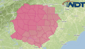
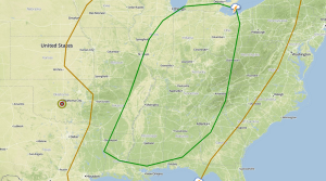
A Tornado Watch has been issued for portions of Northeast Arkansas, Southeast Illinois, Southwest Indiana, Western Kentucky, Southeast Missouri, Northern Mississippi, and Western and Middle Tennessee until 9pm CDT. Several …
Read Storyby WeatherOps, on Feb 20, 2014 1:58:14 PM

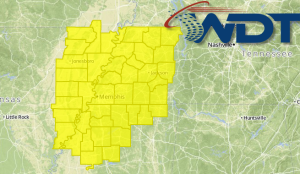
The Storm Prediction Center has issued a Severe Thunderstorm Watch for portions of Illinois and Missouri until 7pm CST. Damaging winds to 70 mph and a few tornadoes will be …
Read Storyby WeatherOps, on Feb 20, 2014 1:21:20 PM

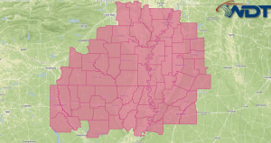
The Storm Prediction Center has issued a Severe Thunderstorm Watch for portions of Eastern Arkansas, Central and Northern Louisiana, Western Mississippi, and East Central and Southeast Texas until 8pm CST …
Read Storyby WeatherOps, on Feb 20, 2014 11:35:35 AM
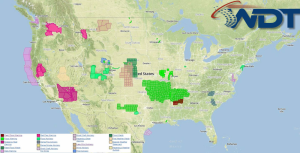
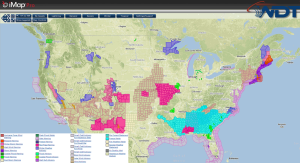
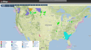
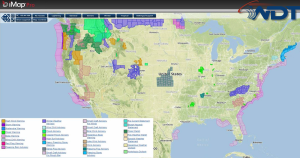
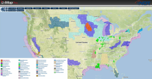
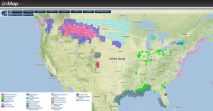
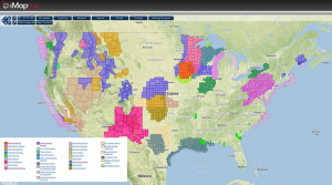
Strong winds are blowing across the Plains behind a cold front. The following image displays all of the wind related advisories currently in effect. Winds could gust as high as …
Read Storyby WeatherOps, on Feb 20, 2014 9:38:06 AM
A severe thunderstorm outbreak is possible today for portions of the Ohio River, Mid-Mississippi River, and Tennessee River Valleys, as well as parts of the Gulf Coast. Damaging winds will …
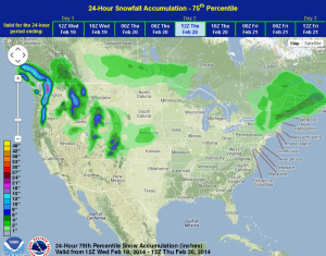
Read Storyby WeatherOps, on Feb 19, 2014 4:12:54 PM

Severe thunderstorms are possible for portions of the Southern Great Lakes and points south toward the Gulf Coast and Mid South. For the Upper Midwest and Mississippi River Valley, blizzard …
Read Storyby WeatherOps, on Feb 19, 2014 2:22:30 PM
Severe thunderstorms are possible for portions of the Mississippi and Ohio River Valleys on Thursday ahead of an upper level trough moving across the Plains. SPC Convective Outlook for Thursday …
Read Storyby WeatherOps, on Feb 19, 2014 9:43:26 AM
Moderate to heavy snow will continue for portions of the Pacific Northwest. For the New England region, a mid-level trough will bring mixed wintry precipitation throughout the day. In the …
Read Storyby WeatherOps, on Feb 18, 2014 3:25:53 PM
Another area of low pressure will bring rain and snow to portions of the Northeast on Wednesday. Strong lift in association with an upper level low will bring a chance …
Read Storyby WeatherOps, on Feb 18, 2014 12:30:32 PM
Severe thunderstorms are possible for portions of the Upper Mississippi River Valley and the Ohio River Valley ahead of an upper level trough that will dig across the Northern Plains …
Read Storyby WeatherOps, on Feb 18, 2014 9:41:26 AM

Moderate to heavy snow will continue for portions of the Northwest as another low pressure system moves into the region. Snow will be possible for portions of the Northeast as …
Read Storyby WeatherOps, on Feb 17, 2014 2:34:30 PM

Light to moderate snow is possible on Tuesday for portions of the Northeast as an area of low pressure continues to lift across the region. In the Pacific Northwest and …
Read Storyby WeatherOps, on Feb 17, 2014 11:56:14 AM
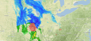
Heavy snow continues to develop over portions of Wisconsin, Illinois, Indiana, and Michigan. In the heaviest snow bands, snowfall rates will exceed 1 inch per hour. Some thunderstorms with sleet …
Read Storyby WeatherOps, on Feb 17, 2014 9:34:11 AM
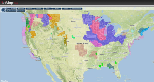
Moderate to heavy snow will continue in the higher elevations of portions of the Pacific Northwest and Northern California as rain continues for the lower elevations. Light to moderate snow …
Read Storyby WeatherOps, on Feb 14, 2014 3:56:15 PM
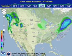
Mountain snows and valley rain will continue for portions of the Pacific Northwest on Saturday where snow amounts could exceed 18 inches in some areas. For the Upper Great Lakes, …
Read Storyby WeatherOps, on Feb 14, 2014 9:41:00 AM
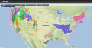
Heavy snow continues across the Northeast as a strong winter storm exits the region. Across the Mid-Mississippi River Valley and the Midwest, moderate snowfall will be likely. Later in the …
Read Storyby WeatherOps, on Feb 13, 2014 12:25:59 PM
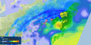
Snow and strong winds are limiting visibilities across much of the Northeast. This is the latest radar and winds. Winds are gusting to near 40 miles per hour in some …
Read Storyby WeatherOps, on Feb 13, 2014 9:51:02 AM
A strong area of low pressure moving northward along the East Coast is bringing significant snowfall to portions of the Northeast, mainly along and northwest of the I-95 corridor. A …
Read Storyby WeatherOps, on Feb 12, 2014 3:24:30 PM
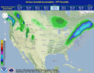
Freezing rain and snow will be likely tonight and tomorrow between I-95 corridor and the foothills of the Appalachians. Moderate to heavy snow will also be possible from Washington DC …
Read Storyby WeatherOps, on Feb 12, 2014 11:31:25 AM
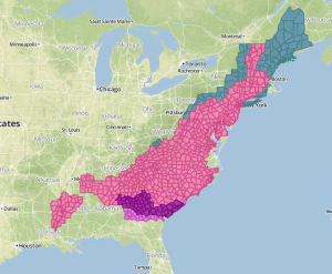
Freezing rain continues for portions of Georgia and South Carolina. Ice Storm Warnings (purple) and Freezing Rain Advisories (pink) are in effect through tomorrow morning. Current NWS Advisories/Watches/Warnings Three quarters …
Read Storyby WeatherOps, on Feb 12, 2014 9:39:29 AM
Moderate to heavy snow is expected today along the Southern Appalachians today. Moderate to heavy ice accumulations are expected for portions of Georgia and the Carolinas. For portions of the …
Read Storyby WeatherOps, on Feb 11, 2014 11:41:12 AM
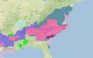
Heavy snow is likely for portions of the East Coast this week as an area of low pressure moves northward along the coast. Up to a foot of snow is …
Read Storyby WeatherOps, on Feb 11, 2014 9:33:38 AM

Light to moderate snow is expected today from portions of the Southern Appalachians and into the Carolinas. Light to moderate icing is also expected through East Texas into the Carolinas …
Read Storyby WeatherOps, on Feb 10, 2014 3:42:07 PM

Heavy rain is likely for portions of the Pacific Northwest. This is an estimation of rainfall amounts from the WDT WRF model. Most areas will see about an inch of …
Read Storyby WeatherOps, on Feb 10, 2014 12:30:21 PM
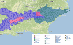
Another winter storm is developing and will affect portions of the Southeast beginning tomorrow. This activity will occur ahead of an area of low pressure moving across the Plains. Freezing …
Read Storyby WeatherOps, on Feb 10, 2014 9:37:45 AM
Light to moderate snow is expected today from Arkansas into the Great Smokey Mountains with light to moderate icing possible from Northern Louisiana to Northern Alabama. In the west, snowfall …
Read Storyby WeatherOps, on Feb 7, 2014 9:47:16 AM
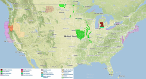
Multiple disturbances will continue to produce moderate to heavy snow across the Cascades, Sierra, and the Northern and Central Rockies as well as heavy rain for portions of California and …
Read Storyby WeatherOps, on Feb 6, 2014 12:37:52 PM
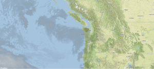
A large storm system will bring up to two feet of snow to portions of the Rockies through Saturday. Infrared Satellite This system will come onshore later today and move …
Read Storyby WeatherOps, on Feb 6, 2014 9:49:56 AM
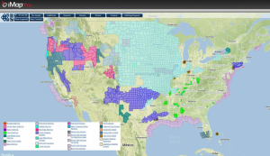
Disturbances moving into the Western US will bring heavy rain to portions of Oregon and California, as well as heavy snow to portions of the Cascades and the Sierra Nevada …
Read Storyby WeatherOps, on Feb 5, 2014 3:35:05 PM
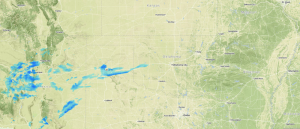
Snow is continuing across the Texas Panhandle and will continue into Western Oklahoma through tonight. Radar 3:10 pm CST Winter Weather Advisories are in effect for portions of New Mexico, …
Read Storyby WeatherOps, on Feb 5, 2014 12:34:16 PM
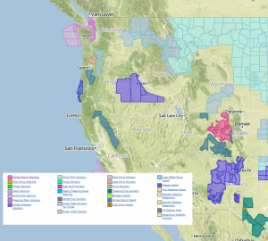
Heavy snow is likely across portions of the Rockies tonight through the end of the week ahead of a trough moving into the Pacific Northwest. Up to 2 feet of …
Read Storyby WeatherOps, on Feb 5, 2014 9:31:25 AM
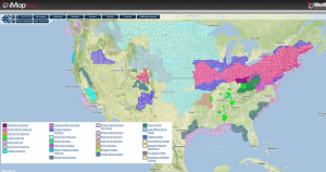
Light to moderate snow will continue for the Midwest and the Great Lakes through the morning and early afternoon. Further to the east over the New England region, moderate to …
Read Storyby WeatherOps, on Feb 4, 2014 9:29:09 AM
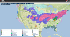
Snow, sleet, and freezing rain will move across portions of the Plains through the remainder of the morning and snow will expand into portions of Nebraska, Iowa, and Missouri this …
Read Storyby WeatherOps, on Feb 3, 2014 2:03:06 PM
An upper level system over the Southwestern US will bring winter precipitation to a large portion of the Plains on Tuesday. Current infrared satellite image from iMapPro Snow will begin …
Read Storyby WeatherOps, on Feb 3, 2014 9:21:28 AM

Moderate to heavy snow will continue through the day today across portions of the Northeast. Further to the south, along the coast of the Mid Atlantic and Southeast, showers and …
Read Storyby WeatherOps, on Jan 31, 2014 4:28:20 PM
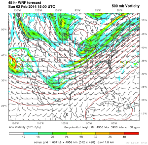
There will be three systems over the next 7-8 days that could bring wintry precipitation to portions of the Plains. The first system will move into the Plains on Sunday …
Read Storyby WeatherOps, on Jan 31, 2014 9:42:51 AM

Moderate to heavy snow will continue across the Central Rockies today ahead of an area of low pressure. Light to moderate snow will continue through tonight for portions of the …
Read Storyby WeatherOps, on Jan 30, 2014 9:34:32 AM
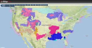
There are two main areas of snow for today. The first is the Pacific Northwest and Rockies where moderate to heavy snow is possible through the day and moving into …
Read Storyby WeatherOps, on Jan 29, 2014 2:24:53 PM
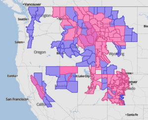
Another winter storm is impacting portions of the Pacific Northwest and Northern Rockies where up to 2 feet of snow will be possible in some places. The heaviest of the …
Read Storyby WeatherOps, on Jan 29, 2014 9:32:29 AM
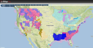
The winter storm that affected the Southeast yesterday will move offshore this morning, but some light snow and icing will be possible from portions of Northern Florida into the coastal …
Read Storyby WeatherOps, on Jan 28, 2014 1:46:26 PM
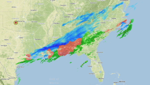
Freezing rain, sleet, and snow is continuing across the Southeast and will continue through early Wednesday morning. Radar 1:15pm CST Sleet will continue for portions of Alabama and Georgia through …
Read Storyby WeatherOps, on Jan 28, 2014 9:46:08 AM

A wintry mix has developed across the Southeastern US overnight and will continue through Wednesday morning. Winter Storm Warnings are currently in effect from portions of Eastern Texas to Virginia …
Read Storyby WeatherOps, on Jan 27, 2014 4:36:41 PM
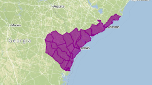
An ice storm Warning is in effect from noon EST Tuesday until 5pm EST Wednesday for the outlined area. Ice accumulations of a quarter to half an inch will be …
Read Storyby WeatherOps, on Jan 27, 2014 1:18:55 PM

A winter storm is taking shape across portions of the Southeast as a bitterly cold air mass continues to move southward into the Southern Plains and Deep South. Here are …
Read Storyby WeatherOps, on Jan 27, 2014 9:40:21 AM
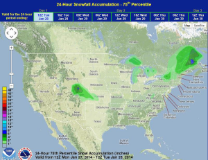
Light snow will persist over portions of New York and Pennsylvania through the day today; up to 6 inches of snow will be possible through tonight. A shortwave trough will …
Read Storyby WeatherOps, on Jan 24, 2014 1:52:38 PM
Snow will be likely for portions of the Ohio River Valley and the Northeast extending from Ohio to New York ahead of an upper level low over portions of Eastern …
Read Storyby WeatherOps, on Jan 24, 2014 9:41:07 AM
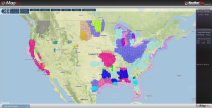
Freezing rain, sleet, and snow will continue for portions of the Gulf Coast through late morning or early afternoon today. Many of the Winter Weather Advisories and Winter Storm Warnings …
Read Storyby WeatherOps, on Jan 23, 2014 12:16:48 PM
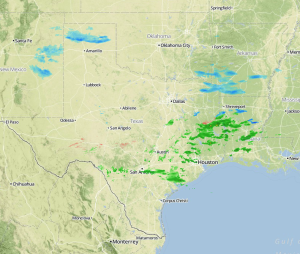
Rain across Southern and Eastern Texas will change over to freezing rain, sleet, and snow later tonight. This was the radar at 11:45am CST. The transition from rain to sleet …
Read Storyby WeatherOps, on Jan 23, 2014 9:51:09 AM
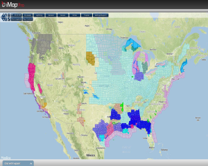
There won’t be much in the way of precipitation today, with the exception of portions of Texas and the Great Lakes. Ongoing lake effect snow over the Great Lakes will …
Read Storyby WeatherOps, on Jan 22, 2014 3:59:14 PM
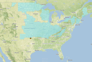
Wind Chill Advisories are in effect for many portions of the country. Below is a look at all of the current advisories. Wind Chill Advisories in iMapPro Wind chill values …
Read Storyby WeatherOps, on Jan 22, 2014 9:51:18 AM
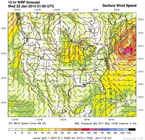
The winter storm that affected much of the Northeast yesterday is beginning to wind down, but another system will bring blizzard conditions to portions of the Dakotas and Minnesota today …
Read Storyby WeatherOps, on Jan 21, 2014 3:50:54 PM
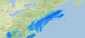
Heavy snow is continuing for portions of the Northeast and snowfall rates are as high as 1-2" per hour. Radar 4:30pm EST For most of the day, the snowbands have …
Read Storyby Steve Miller, on Jan 21, 2014 3:24:26 PM
Chicago, southern Cook County and northwest Indiana were hit with an intense band of lake-effect snow overnight driven by gusts of more than 30 mph. As of 6 a.m., 59 …
Read Storyby WeatherOps, on Jan 21, 2014 9:39:57 AM
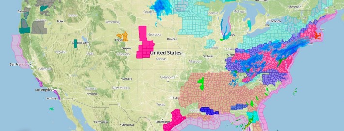
A large upper level system over the Great Lakes and the Ohio River Valley will bring heavy snow to portions of the Northeast and south into portions of Virginia. At …
Read Storyby WeatherOps, on Jan 20, 2014 2:42:31 PM
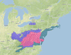
A winter storm is taking aim on portions of the New England regions and into the Appalachians. Winter Storm Watches and Warnings, as well as Winter Weather Advisories are in …
Read Storyby WeatherOps, on Jan 20, 2014 9:52:58 AM

Lake effect snow will be possible today for portions of the Great Lakes as a fast moving system moves across the Northern Plains today. Up to 8 inches of snow …
Read Storyby WeatherOps, on Jan 17, 2014 9:49:18 AM
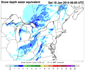
The blizzard conditions that affected portions of the Dakotas and Minnesota yesterday have subsided, but some light snow is still possible for portions of Iowa, Minnesota, South Dakota, and Wisconsin …
Read Storyby WeatherOps, on Jan 16, 2014 3:01:48 PM
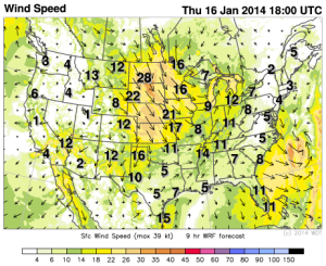
Another clipper will move into the Great Lakes. Light snow and blizzard conditions will be possible for portions of the Dakotas, Minnesota, and Iowa. Winds could gust over 50 miles …
Read Storyby WeatherOps, on Jan 15, 2014 11:29:17 AM
1/15/14: A strong low and trough in central Canada slowly moving southeast into the US will allow for some snowfall in Minnesota through Wisconsin and Michigan, but amounts should remain …
Read Storyby Steve Miller, on Nov 6, 2013 4:26:28 PM
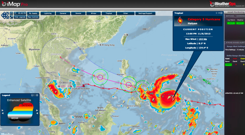
Super Typhoon Haiyan is set to make landfall on Friday in the Central Philippines packing sustained winds of 155mph and a 10' storm surge. With 160mph winds at this time, …
Read Story